
EWELL HERITAGE TRAIL
SECTION 3: MILL LANE TO DORSET HOUSE CAR PARK
 The Ewell Heritage Trail.
(Click to enlarge)
Mill Lane (reached either by crossing the road at the end of Section 1 or where you arrive at the end of Section 2) contains many weatherboarded cottages, most from the early nineteenth century, while one masks a medieval building behind the white boards. There are also workers’ cottages built more substantially in flint and brick.
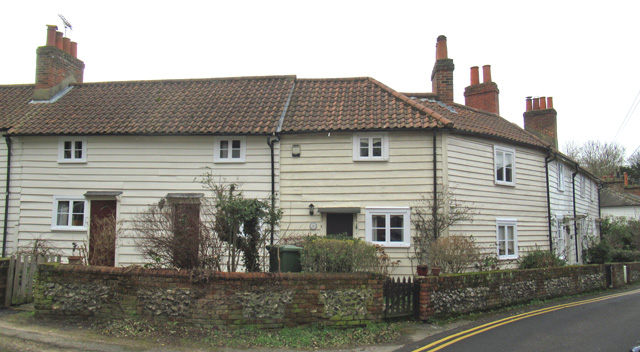 Weatherboarded cottages in Mill Lane.
Photographs by Roger Morgan © 2023
You then reach the busy London Road, across which is Parish Church of St Mary. Before crossing the road, walk a few yards to your left to read Storyboard E about the church.
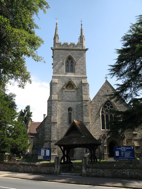 St Mary’s Church.
Photograph by Peter Reed © 2013
The text of Storyboard E is: There has been a church St Mary’s since the eleventh century, and it was remodelled many times in the Middle Ages. But in 1848 the vicar, Sir George Lewen Glyn, who was also a major landowner, wanted a larger building, and persuaded the parish vestry to pull down the old one. As a concession to local feeling, the tower of the original church was kept. It has a brick parapet and a weathervane fitted in 1789 by the blacksmith Richard Bliss, who lies buried close nearby.
The fifteenth century font and chancel screen were moved to the new church, along with monuments and brasses as well as the bells, which had been recast as a ring of six in 1769. Over the next fifty years, the new church was beautified by presents from the Glyn family and other local dignitaries. Edward Martin of Nonsuch Court Farm gave the pulpit, and the Torrs of Bourne Hall presented the organ.
For many years, Ewell had two churchyards, one around the old church and one beside the new one. The Tudor building of Rectory Farm separated the two. This was the home of the Woodmans, uncle and aunt of William Holman Hunt, the Pre-Raphaelite artist, who often visited them in Ewell. In 1905, the old farm was demolished and its grounds were laid out for burials.
Across the road from the church, the parish hall was built in 1895. At this time the church also supported West Street School, the clothing and coal clubs, the village nurse and a coffee tavern set up to keep working men out of the local pubs.
Cross the road and enter the church grounds through the lychgate. As noted on the storyboard, St Mary’s was built in 1848 to replace the original medieval building. Follow the path (on the right of the church) through the churchyard. Before long, the path runs parallel to Church Street on your left and, set back behind the houses, you will see an old wooden barn. This is all that is left of Rectory Farm (16), where William Holman Hunt stayed with his relatives.
 All that remains of Rectory Farm (16).
Photographs by Roger Morgan © 2023
Continuing along the path, you enter the earliest section of the churchyard, containing the fifteenth-century tower which is all that remains of Ewell’s original church (17).
 All that remains of the old St Mary’s (17).
Photograph by Roger Morgan © 2023
It was not thought right to fix the usual plaque to the lower itself, and it is on the pillar (over your right shoulder from the view above) as you leave the churchyard and enter Church Street.
 The plaque for the old St Mary’s tower (17).
Photograph by Roger Morgan © 2023
As you enter Church Street you will see, across the road, a long building with stucco battlements in early nineteenth-century style. This is Ewell Castle School (18), an early work of Ewell’s neglected architect Henry Kitchen.
 Ewell Castle School.
Photograph by Roger Morgan © 2023
Walking down the street away from the main school building, you next pass, on your left, what is now another part of Ewell Castle School, but which was originally the St Mary’s Vicarage, known as Glyn House after the 19th Century Vicar, Sir George Lewen Glyn.
 A 19th Century view of Ewell’s then Rectory House.
Image courtesy of Bourne Hall Museum
Next to that is a house with a bay window – originally a coaching inn, the Kings Head. On the other side of the road is Well House (19), an early example of a semi-detached plan.
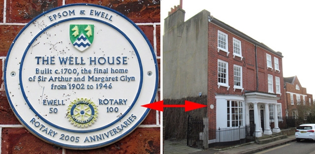 The Well House.
(As noted on the plaque, this was the home of Sir Arthur Glyn.)
Photographs by Roger Morgan © 2023
After that comes another house with mathematical tiles [see the Note in Section 1] , set back from the road (and seen on the right of the photograph above), and then the Old Malthouse where barley was processed for local brewers, now St Michael’s the Sanctuary (20).
 St Michael’s the Sanctuary.
Photographs by Roger Morgan © 2023
After two more buildings with mathematical tiles is the village Watch House (21). This has two doors, one on the left with bars for a temporary lock-up and one on the right for the Ewell fire engine, which can be seen today at the Bourne Hall Museum.
 The old Watch House and, to the left, the one of the houses with “mathematical tiles” mentioned above.
Photographs by Roger Morgan © 2023
Turning left at the corner, you pass the Neapolitan Kitchen (22), formerly a pub, the King William IV. The King is said to have stayed at Ewell, admiring the white cattle kept by Charles Hall at the Upper Mill.
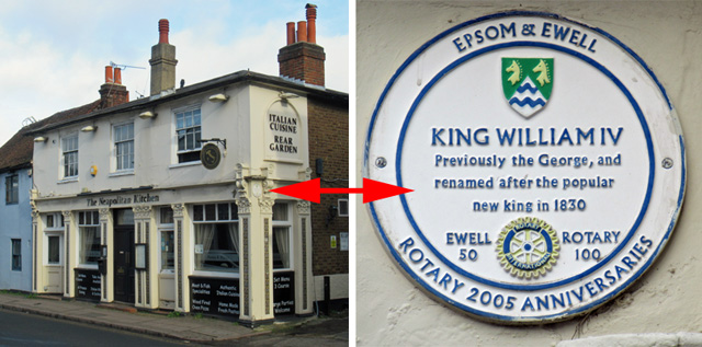 The former King William IV pub.
Photographs by Roger Morgan © 2023
 The King William IV pub (its sign arrowed here) in about 1910.
From a postcard in Linda Jackson’s collection.
A little further on is a solicitors [in 2023, Freedman Alexander LLP], where the village Coffee Tavern traded in competition with local pubs. The shop with a bay window opposite [in 2023, part of the Burghwood Clinic] housed the first parish offices.
Continue on the High Street as it turns to the right, and then widens into a small green space. These are the Gertrude Longhurst Memorial Gardens (Storyboard F).
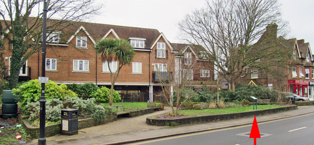 The Gertrude Longhurst Memorial Gardens with, as arrowed, the Trail’s standard storyboard.
Photograph by Roger Morgan © 2023
The text of Storyboard F is: Here, in the Gertrude Longhurst Memorial Gardens, the first Congregational Church for Ewell was built in 1865. John Carr Sharpe, who laid the foundation stone, was manager of the gunpowder mills on the River Hogsmill. The church expanded and ten years later a Sunday School and Lecture Hall was built next to it. Eventually, the site was felt to be too small and, in 1937, a new building (the present United Reformed Church) was opened in London Road. This site was bought by Stanley Longhurst, and made into a memorial garden for his wife. During World War 2, the [now lost] buildings at the back were used as a shadow factory, where aircraft components could be made without attracting the attention of enemy bombers.
Over the road was a builder’s yard, set up in the early years of the nineteenth century, which was the premises of Goodship and Saunders from the 1910s until 1993. They amalgamated some cottages to form the main building block, with a long workroom over it, now divided into flats. At the front was a barn, used by Charman the butcher, which was pulled down and is now rebuilt as offices.
Up the road on the far side were terraced houses, one of them a beer house although the landlord catered for all tastes by selling milk from a cow kept in the fields behind. The pub was called the Lord Nelson. It was acquired by Pagdens Brewery in Epsom and rebuilt in 1905, but in 1963 it was demolished and the site is now [in 2023, the Costa Coffee shop, but in 2005] Barclays Bank.
The upper part of the High Street used to be known as Green Man Street after the pub that has been here since 1763; it was rebuilt in the 1930s and is now the “Famous Green Man”. When Ewell Fair was held in October, sheep were penned in the Fair Field behind the pub, and horses stood under the garden wall opposite. The fair ended in 1890.
As noted on the storyboard, the gardens were laid out on the site of the original Congregational Church – which, now long re-named Ewell United Reformed Church, moved to London Road.
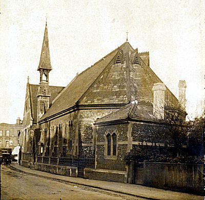 Ewell’s old Congregational Church and Lecture Hall, pre-1938.
Image courtesy of Surrey Libraries and is held in the
Epsom & Ewell Local And Family History Centre Collection.
Continue up the High Street, passing a a run of cottages called the Highway. Then comes the Famous Green Man, a pub which was rebuilt in the 1930s to replace the smaller Victorian “Green Man” beer house.
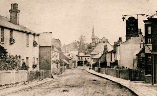 A c.1890 view down what was then called Green Man Street, after the old pub on the right.
From a postcard in Linda Jackson’s collection.
Continue past another parade of shops to the corner with Reigate Road, tum left, and then left again down the zig-zag residential street of Staneway. (As noted at the beginning of the Trail, Staneway was named after Stane Street – the Roman road that ran from London to Chichester and created the original settlement at Ewell.)
The other end of Staneway comes out on Cheam Road which, to the right, continues out of the village to join the Bypass. However, turn left towards the centre of Ewell and, within a few yards, find the old Grove Cottage (23) on your left.
 Grove Cottage.
Photographs by Roger Morgan © 2023
A little beyond that is The Star (24), a seventeenth-century building which has been a bank, post office, wine bar and clinic in turn [in 2025, the Burghwood Clinic].
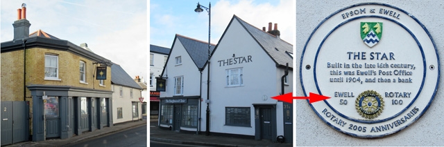 The Star.
Left: the frontage on Cheam Road. Centre: round the corner, on the High Street.
Photographs by Roger Morgan © 2023
That completes the Heritage Trail. (Just across the road is where it begins, in the Dorset Road car park.)
Section 1: Dorset House car park to the Upper Mill
Section 2: Western loop from the Upper Mill to Mill Lane
Section 3: This page
Developed from the original text by Roger Morgan, 2023