
EWELL HERITAGE TRAIL
SECTION 1: DORSET HOUSE CAR PARK TO THE UPPER MILL
 The Ewell Heritage Trail.
(Click to enlarge)
The Ewell Heritage Trail begins at the Dorset House car park (Storyboard A) on Cheam Road, opposite Staneway, which was named after Stane Street – the Roman road that ran from London to Chichester and created the original settlement at Ewell.
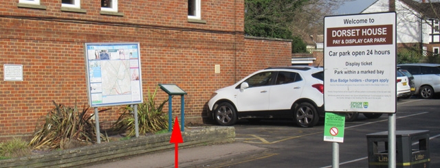 Dorset House car park with, as arrowed, the Trail’s standard storyboard.
Photograph by Roger Morgan © 2023
The text of Storyboard A is: This car park was laid out in the garden of Dorset House, now demolished; it stood where number 9 High Street is now, and was the home of Charles Warne the Dorset archaeologist. Christ Church (previously Staneway Chapel) was built in 1955. Nearer the village, there was a timber-framed building at number 5 High Street, which was first a long jettied hall, with chimneys and a newel staircase added afterwards on the side away from the road.
Towards Cheam stood Ewell Grove House, which was demolished in 1937 when The Portway was built on its site. The gardens extended into a pit which was dug in the middle ages to provide chalk for masonry. Later, the chalk was used for mending roads and burning into lime to make fertiliser. Ewell Grove House was built for John Pollard in the 1780s. It had a large yard and stables with a farmer; at the far end of the pit there was an ice house. It was the home of the Reids until 1869, and Lady Reid [wife of Sir John Rae Reid, 2nd Baronet] was the last person in Ewell to use a sedan chair.
On the far side of the road, where numbers 18-22 High Street are now, stood the Manor House, also in one of the chalk pits. The Lamprieres lived there; they came from Jersey and had connections with John Millais, the Pre-Raphaelite painter, who used to stay in the house. [See The Pre-Raphaelites] Captain Lampriere had a large family and, over the years, had got into the habit of adding a new room to his house every time that the birth of a new child made it seem necessary.
Cross over Cheam Road and turn left until you come to a footpath on the right – Mongers Lane – by Pit House (1).
 Pit House.
Photographs by Roger Morgan © 2023
Mongers Lane is an old bridleway which was once the main route from the village of Cuddington to Epsom. Part way along this, cross Reigate Road and continue to where the bridleway joins the Epsom Road. In your left as you join Epsom Road is the Old House (2) of 1810, which housed Monger’s Academy, a private school for the children of Nonconformists.
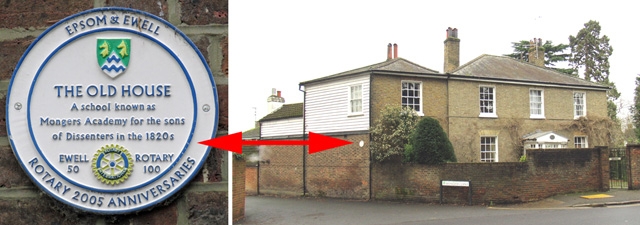 The Old House.
Photographs by Roger Morgan © 2023
Cross over Epsom Road and turn right. As you come downhill, you will come to a lane [Tayles Hill Drive] on the right that curls anti-clockwise to Tayles Hill House (3). It is worth stepping aside to see this fine early nineteenth-century building, originally the home of the Lloyd family. Until the 1960s, an apartment here was the home of James Chuter Ede (later Baron Chuter-Ede), born and bred in the Borough and, among many other things, the creator of the Labour Party’s post-war education policy.
 Tayles Hill House and James Chuter Ede’s memorial plaque (partly hidden by the porch light).
Photographs by Roger Morgan © 2023
After some shops, you come to a green space lined with trees on your left – this is The Grove (Storyboard B).
 The Grove, with, as arrowed, the Trail’s standard storyboard.
Photograph by Roger Morgan © 2023
The text of Storyboard B is: The Grove is an open space, lined with lime trees, linking the High Street with West Street The trees are three hundred years old, although many have been replaced. Ropemakers from the saddlery in West Street used to stretch their ropes out under the shade of the trees.
Near this spot, a captured enemy gun was brought after World War 1 to stand as a monument, and it remained here until World War 2 when it was melted down for munitions and returned to its original makers in a slightly different form.
To your right is the playground of Ewell Grove School. This was built in 1912 for the Girls and Infants section of the original village school which can be seen further down West Street [at point 4 of the Trail]. To your left is a brick wall, much rebuilt but going back to about 1680 when Mr Femdall built a mansion called Ewell House behind it. In the nineteenth century a coach house and lodge were built next to the mansion in the Tudor style, and these are still standing although the house itself was demolished in 1960. It had an icehouse and a network of tunnels running through the grounds, but in 2000 these became dangerous and had to be filled in.
The Grove follows a medieval routeway which continues down the alley to Spring Street. This area was used as a cemetery from the sixth century until the building of St Mary’s Church [at point 17 of the Trail], and pagan Saxon burials with spears and ornaments have been found here.
Turn down The Grove towards West Street, passing by the playground of Ewell Grove School on your right and on the left the Victorian lodge to Ewell House. The house itself is now gone, but the lodge and servants’ buildings behind it are an attractive attempt at Tudor decoration. Ewell Grove School was originally built for the girls’ section of the village school. At the end of The Grover, turn right down West Street and you will soon come to the old Village School (4) itself, built in 1861 out of charitable funds, supplemented by Sir George Glyn the vicar. It is now converted into flats.
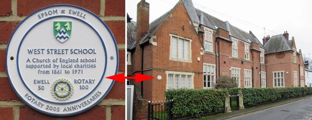 The old Village School.
Photographs by Roger Morgan © 2023
A little further on to your left is an archway (5) which had metal tramlines running through it. This is where the heavy machinery for Jamesons Light Engineering Works was wheeled in and out.
 The former Jamesons works.
Photographs by Roger Morgan © 2023
At the end of West Street turn left into the High Street. The beauty salon on that corner looks as if its High Street frontage was brick-built. It is in fact clad with mathematical tiles.
[NOTE: “Mathematical tiles”– as mentioned at several points in this guide – are specially shaped overlapping tiles which, when nailed to a wooden building and the spaces between them are filled with mortar, are effectively indistinguishable from ordinary brickwork. The origin of the name is uncertain, but thought to relate to their precision.]
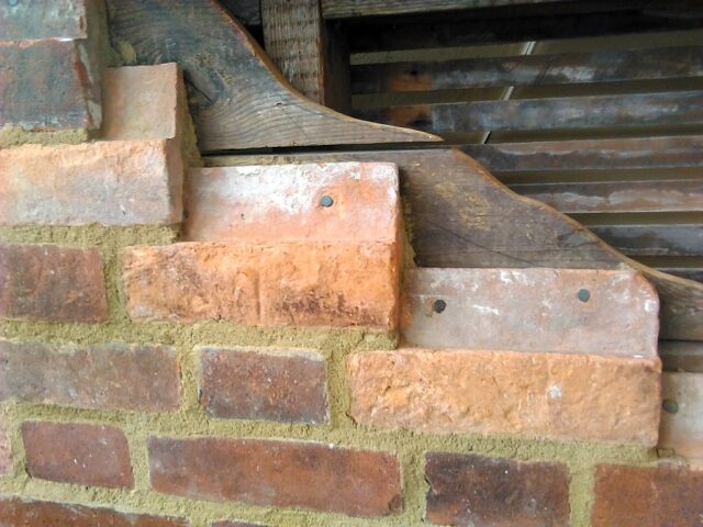 Display of mathematical tiles at Bourne Hall Museum.
Photograph by Lord Belbury, CC BY-SA 4.0, via Wikimedia Commons ]

The next building down the High Street on your left is Mary Wallis House (6), a seventeenth-century house improved with slight bay windows. It was occupied by members of the Stone family but is named after their servant girl. Mary Wallis was a remarkable woman who saved enough money from her wages to build a now-lost chapel in West Street.
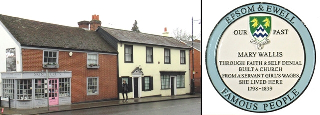 On the left here is the mathematically tiled frontage mentioned above. “Mary Wallis House” is the cream painted building. On the right is a plaque waiting to be displayed on what is now 24 High Street.
Photographs by Roger Morgan © 2023
The pavement then runs past a long brick building, rebuilt in about 2000. This was the granary where the Stones stored their grain supply. Over the road, on your right, is a run of fine seventeenth century cottages, ending in number 9. This was formerly an inn, called the Red Lyon (7).
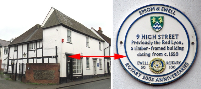 The former Red Lyon at No 9 High Street.
Photographs by Roger Morgan © 2023
Carry on past the shops and turn down Spring Street, which has two elegant Georgian buildings. The first is Spring House (another building faced with mathematical tiles to look like brick), now converted into flats. The second is Chessington House (8), once the home of Albert Nicholls the conservationist.
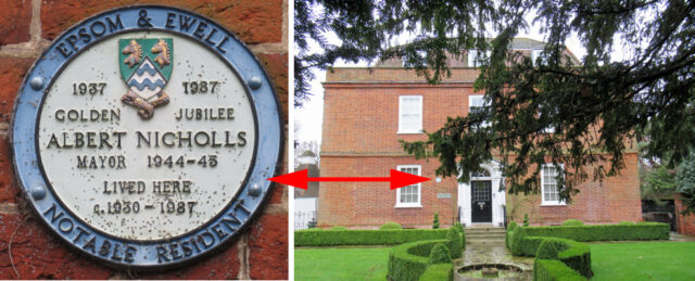 Chessington House.
Photographs by Roger Morgan © 2023
Return to the High Street end to cross the busy Spring Street, and then enter the grounds of Bourne Hall through the tall Dog Gate. This was built in the 1820s by Hercey Barritt – the then resident in the original Hall [called Garbrand Hall] – whose coat of arms is displayed on the Gate. He also built the artificial bridge which takes you over the lake. The Lodge (9) to your left was built by the Torr family a little later in about 1860. The old Hall where they lived was demolished in the 1960s. The new Bourne Hall community centre opened in 1970 and, among other things, contains the Bourne Hall Museum of local history.
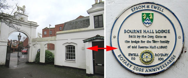 The Dog Gate into Bourne Hall grounds and Bourne Hall Lodge.
Photographs by Roger Morgan © 2023
Carry on round the lake and you will come to an arch for an ornamental waterwheel. Just past this there is a paved area with an old stone seat where you can rest and contemplate the wildfowl on the Horse Pond.
At the road turn right, then cross the road to follow the footpath alongside what is now the Hogsmill river, which will be on your left. Before long, you will come to the Upper Mill (Storyboard C), a reconstruction of the original building which was pulled down in 1984. The mill supplied stone-ground flour until the 1930s and claimed to have served Queen Victoria.
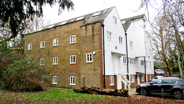 The rebuilt Upper Mill (from about the location of Storyboard C).
Photograph by Roger Morgan © 2023
The text of Storyboard C is: The Hogsmill was a powerful stream in the early Middle Ages when it turned several mills at the head of the course, but in 1408 there were only two – the Upper and Lower Mills. In the eighteenth century, the Lower Mill was used by the Jubb family for making paper. They rebuilt the mill, which is now demolished, as well as the family home, which still stands.There were separate buildings to store, wash and bleach the rags, and the long tank between the two mills may have been used for this.
The Upper Mill was rebuilt in about 1810, when Sarah Hall was miller. The river flowed through the building, turning a central wheel, and working six stones. The mill ground five wagon loads of wheat every day – much more than was needed for a country village like Ewell, but their flour also sold in London. In 1832, after the Lower Mill had given up making paper, Hall & Davidson bought it and installed new cast iron machinery. This mill was rebuilt in brick, instead of timber, in 1896, and the millstones were replaced by roller plant, which produces white flour rather than wholemeal.
By 1925, water levels had dropped, due to extraction to supply the new suburbs, and the mill could only work in the daytime. The Lower Mill burnt down in 1938, while the Upper Mill continued on a small scale until 1953. It continued in use as a store until 1984, when it was substantially pulled down and rebuilt for use as offices.
[NOTE: Click this link for a detailed history of the Upper Mill – and of the Lower Mill, the ruins of which are passed in Section 2 of the walk.]
If you want to continue the short walk – the second part of which is Section 3 – cross over the road to go down Mill Lane.
 Mill Lane, across the Road from the Upper Mill – with, as arrowed, storyboard C.
Photograph by Roger Morgan © 2023
Section 1: This page
Section 2: Western loop from the Upper Mill to Mill Lane
Section 3: Mill Lane to Dorset House car park
Developed from the original text by Roger Morgan, 2023