
ROSEBERY PARK

The L-shaped Rosebery Park in April 2011, from the northwest.
(To the left is Ashley Road and the UCA; in the bottom left is the Ashley Centre and Ashley Avenue; and, bottom right, is the A24 to Ashtead.)
Aerial photograph with thanks to Bourne Hall Museum.
Lord Rosebery (1847-1929) is such a significant figure in the late 19th and early 20th century life of Epsom that he is mentioned in many articles on this website. Those articles also make a number of references to the central Epsom park that bears his name. However, this article concentrates on the park itself.
 The Council’s welcome board and map as displayed in the Park.
(Click to enlarge)
If you know the background of the Rosebery connection with Epsom, skip to the next paragraph. For those coming to this fresh, Lord Rosebery (formally, the 5th Earl of Rosebery – being Archibald Philip with the family name of Primrose) was a most illustrious figure in society, politics – including a year as Liberal Prime Minister in 1894/95 – and horse-racing circles. The Rosebery ancestral home was in Dalmeny, near Edinburgh, but it was Epsom’s racing connection that led him to purchase The Durdans in 1872. Of his many properties, this became his real home. In 1878, he married Hannah de Rothschild (of the banking family and “the richest woman in England”). They had four children: Sybil; Margaret (known as Peggy); Harry (who became the 6th Earl); and Neil (a WW1 casualty). Hannah died suddenly in 1890, aged only 39. The distraught Lord Rosebery never remarried. He died at The Durdans in 1929, aged 82.
The park’s story needs to begin with the 1899 marriage of Lord Rosebery’s 18 year old daughter, Peggy, to his close political colleague, the widowed 41 year old Marquis of Crewe. While the Crewes had a number of properties, Lord Rosebery wanted Peggy also to have a base in Epsom. It was for this purpose that, at auction on 11 June 1913, he purchased Woodcote Hall, at the junction of South Street and Woodcote Road. The property (shaded pink in the plan below) had been advertised in the Times in the following terms:
“Woodcote Hall an old-fashioned residence standing in beautifully matured grounds of nearly 20 acres, a portion of which could be advantageously utilised for the erection of villa residences, which are in considerable demand in the neighbourhood, without detriment to the remainder of the property…Woodcote Hall with about 8¼ acres is let at £300 p.a. Immediate possession of the remainder could be obtained… Vendors solicitors, Messrs Murray Hutchins Stirling & Co., 11 Birchin Lane, EC.”
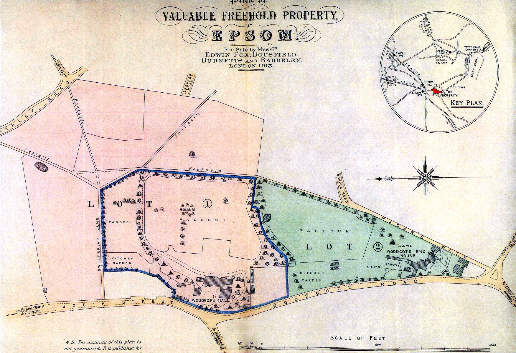 The plan (NB in which north is to the left) that was part of the 1913 sales particulars
relating to Woodcote Hall, being LOT 1, the area shaded pink.
(Lot 2, shaded green, relates to the separate sale of Woodcote End House.)
Click image to enlarge
Image courtesy of James Hakim © 2012
After describing the residence and outbuildings, the detailed sales particulars extolled the virtues of the “Matured Park-like Grounds” as below.
“Well planted with Fir, Horse-Chestnut, Pine, Elm, Lime, Holly and other trees, with LAWNS, FLOWER BEDS, GRAVEL WALKS, TENNIS LAWN and Enclosures of Sound PASTURE LAND. The Property comprises in all an area of nearly 20 Acres of eligible Land: the Residence and Grounds, about 8½ Acres, affording at the present time a most enjoyable occupation; while the remainder, about 11¼ Acres is absolutely RIPE FOR IMMEDIATE DEVELOPMENT by the erection of Attractive Villa Residences which are in considerable demand in the neighbourhood and which, it is anticipated, would readily sell at remunerative prices, Woodcote Hall and its immediate grounds not in any way being interfered with nor depreciated.
“The Residence and Gardens, about 8½ Acres – edged Blue on the Plan – are let on Lease for a Term of 21 Years from 29th September, 1906, determinable by the Lessee at the end of the 14th Year, or Six Calendar Months’ Notice, at a rental of £300 per Annum.
“The remainder of the Land, about 11¼ Acres, being let on Agreement to 25th March, 1914, determinable by the Lessor on the 29th of September nest, or on any subsequent date on 3 months’ notice, at a Rent of £25 per Annum.
“There is a Land Tax of 16s. 10d. per Annum, and the commuted Tithe Rent Charges are: Rectorial, £5:11:5 [£5.57]; Vicarial, £4:11:8 [£4.58].“
(Those “Tithe Rent Charges” arose from the easternmost area of the site being, as noted on the 1866 OS map extract below as “Glebe” land either owned by the local church – St Martin of Tours – or, as here, the profits therefrom being reserved to the church; in either case, to help support the parish priest.)
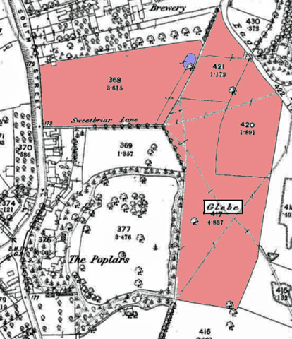
An extract from the 1866 OS map (when Woodcote Hall was known as “The Poplars”)
in which the future Rosebery Park is shaded pink.
Far from taking up the vendor’s suggestion of developing Woodcote Hall’s outer grounds (the last part of Epsom’s medieval Common Fields) for “the erection of Attractive Villa Residences“, Lord Rosebery separated these 11¼ acres from Woodcote Hall and its immediate grounds and, on 30 September 1913, wrote to Epsom Council offering the land for use as a park. The Earl was now in his mid-60s and had suffered some fallings out locally following his opposition to the turn of the century development of the “Epsom Cluster” of mental hospitals. He hoped that the town of Epsom would accept the gift, adding that: “I have of late rather lost my old intimate connection with Epsom, so I am all the more anxious to give this proof of my deep and abiding affection for the place and the people.”
(As an aside, after the Crewes sold Woodcote Hall in the 1920s, the new owner developed a large part of the inner grounds of the Hall for housing on the new Woodcote Close, part of which can be seen in the top right of the aerial photograph at the head of this article. )
Lord Rosebery’s reasons for his generous gift – accompanied by the offer of £500 towards the cost of laying out the grounds – were more than stated in his letter. At the instigation of the London Traffic Branch of the Government’s Board of Trade, a new road had been proposed to bypass Epsom Market Place – in particular, to avoid the bottleneck at the South Street/High Street corner which, even in the moderate traffic conditions of 1913, had been giving problems. The proposed new road would have run from the bottom of Ashley Road across the common fields to join the beginning of Dorking Road at the junction of South Street and Woodcote Road. This would have run very close to the gardens of Woodcote Hall, disrupting their seclusion and peace. That proposal would, of course, be blocked by the Council’s acceptance of Lord Rosebery’s gift.
At the same time, there were other pressures on Epsom Council. In January 1913, it had been approached by the London Society to ask for co-operation in “securing the best possible distribution of Open Lands” together with a request for a local plan showing not only land already dedicated to the public but also other areas which the Council thought it would be desirable to secure permanently. Among the latter were these last remnants of the medieval Common Fields. Indeed, before the sale of Woodcote Hall and grounds at auction on 11 June 1913, the Council had been offered the property for £8,000 – which it had rejected as being too expensive.
The Council meeting on 9 December 1913 noted that the formal transfer of the land had been completed in a Conveyance dated 26 November, and acknowledged the conditions imposed by Lord Rosebery – namely: that it was to be used and preserved as a public pleasure ground for the resort and recreation of the people of Epsom; no organised games or entertainments were to take place; and there should be nothing with might be an annoyance to the present or future occupiers of Woodcote Hall.
(As another aside, the stipulation about no organised games was not observed for long. Soon after the Park’s opening, goalposts were set up for local football teams – and stayed up despite Lord Rosebery’s objections. Relations with the Council cooled. When the need to extend Epsom Cemetery arose in the early 1920s and the only feasible land was owned by Lord Rosebery, local tradition has it that he would have given the land as a benefaction. However, he made a point of selling the area for the market price – but immediately gave away the realised £2,000 for charitable purposes: Epsom & Ewell Cottage Hospital benefited with a new extension, and work on the chapel at Epsom College was completed.)
On 15 December 1913, John Hatchard-Smith, Chairman of the Council, sent out many letters noting that the cost of laying out the Park so generously donated by Lord Rosebery would be considerably more that the £500 he had also given with the hope that addressees would contribute to the work so that none of the cost would have to be met from the rates (the then local property tax).
The Council set up a sub-committee to arrange the laying out of the grounds. Work started immediately with the fencing between the old fields taken down so that the public could begin to use the park in the summer of 1914. Advice on laying out the ground was sought from Mr J A Gardiner (the Superintendent of Hyde Park, Kensington Gardens, St James’s Park and Buckingham Palace). His wish to re-align some of the well-used footpaths was turned down but, otherwise, his recommendations were implemented. In the early months of 1914, entrance gates were erected in the centre of the South Street boundary. Trees and shrubs were planted and the long-standing small pond (see the 1866 map above) was enlarged and stocked with fish from Woodcote Park. In May 1914, the park was formally named “Rosebery Park”.
In spite of the outbreak of WW1 in August 1914, work continued. In 1915, a now-lost pavilion was built; the pond was further enlarged to its current size; and more trees were planted. A Mr Knight was appointed as Park Superintendent on 25/- (£1.25) a week. With men in short supply, eight female workers and their children were employed to weed and tidy the borders.
A bandstand was erected near the entrance of the park and military bands played regular concerts there. The park was used by many soldiers from Woodcote Park Camp, at first the University & Public Schools Brigade and then the convalescents. The latter weren’t disabled in all respects and, by 1916, so many of them had taken to meeting their girlfriends in the park that the Police were requested to secure decency and order there. More prosaically, part of the unused ground within the park was ploughed up and planted with potatoes.
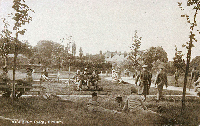
Postcard of soldiers convalescing in Rosebery Park during WW1.
Image with thanks to Bourne Hall Museum.
When the war was over, the allotments were filled in and replanted. The Park began to mature.

An early 1920s postcard of Rosebery Park. (Note the “old technology” lawn mower.)
In the left background, across South Street, is part of what later became Mounthill Gardens.
Image with thanks to Bourne Hall Museum.
1927 saw the erection of a better bandstand, being one used at the 1924 British Empire Exhibition at Wembley – and bought for £10 (plus carriage).

A late 1920s postcard, looking east across the pond to the new bandstand.
(The interesting building in the right background is “Tower House“.)
Image with thanks to Bourne Hall Museum.
Sunday band concerts were very popular – although there were some complaints from the local churches about the music disturbing the evening services. It was suggested that the start of the concerts should be delayed until 7.30, but the Council decided that in the interests of parents and children, an early start was desirable.

Rosebery Park from the air, 1928
Aerial photograph with thanks to Britain from Above
The bandstand and pond are clearly seen in the 1928 aerial photograph above, and those features help orientate the extract from the 1932 Ordnance Survey map below – the bottom left corner of which shows the late 1920s Woodcote Close constructed in the inner grounds of Woodcote Hall.

An extract from the 1932 OS map
Some particular points of interest are numbered on this map. The key to those is below.
1 is the now-lost bandstand. This was surrounded by a fenced area, entry to which was charged for during the band concerts.
2 is the now-lost pavilion.
3 is the then Park Keeper’s cottage – now a private residence, as may be seen on the left in the picture below. (It may also be seen on the extreme right of the late 1920s postcard above of the pond and bandstand.)
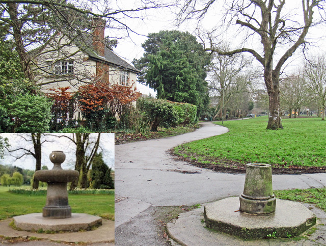
See notes on 3 above and 4 below.
Main photograph © Roger Morgan 2020.
Inset with thanks to Bourne Hall Museum.
4 is one of the three short-lived drinking fountains. While the others, also marked “D.Fn” are now completely lost, the base of this one remains – as shown above. The inset is of the fountain in its original state, about which there is more in our article on the Borough’s Drinking Fountains and Cattle Troughs.
5 is Sweetbriar Lane (the line of which is also coloured red) – the only explicitly named right of way in the Park. (The path that, from the end of that Lane, runs south along the edge the Park towards Woodcote is labelled on the 1932 OS map as the continuation of Madan’s Walk. That Walk starts alongside Woodcote End House – the green-shaded Lot 2 in the plan of 1913 sales near the head of this article – an early resident of which was the Revd Martin Madan.) It is thought that Sweetbriar Lane was named centuries ago as an important right of way providing access to the medieval common fields past the copyhold area to the north of the lane – and now part of the park – long known as Readings Mead and which, as traced in our article on Woodcote Hall, eventually became part of its grounds.
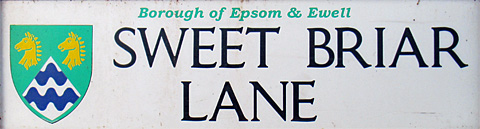
The sign for Sweet Briar Lane at its junction with South Street.
Photograph by Roger Morgan © 2020
During the 1930s, it became increasingly clear that the 1914-18 Great War had not been the “war to end wars”. During the September 1938 Munich crisis, air raid trenches were dug in Rosebery Park, and an anti-aircraft company came in from London to use the area for training. Within three months of the start of WW2 in September 1939, part of the Park had been turned into allotments – some of the 229 across the Borough’s eight parks. In 1940, a bylaw allowed the park gates to be left open at night for access during air raids: by July 1940, the gates had gone for much-needed scrap, along with three tons of other railings “serving no useful purpose”.
After WW2, Rosebery (like the Borough’s other parks) was fully restored for peacetime use.

A 1980s postcard of Rosebery Park.
Image with thanks to Bourne Hall Museum.
The above 1980s postcard (looking west from the Ashley Road side) shows that “normal service” had been resumed. However, the pre-war bandstand had been lost and its position taken a new rose bed, on the left of the image. Since then, cost pressures have led to planting schemes being simplified, with the main features being the raised beds each side of the entrance from South Street.
In 2011, four new memorial seats were installed around a couple of established trees near the South Street entrance to mark some important forthcoming anniversaries: three in 2012 (the Queen’s Diamond Jubilee, the 75th anniversary of the Incorporation of Epsom & Ewell and the 75th anniversary of Nonsuch Park); and the 2013 centenary of the gift of Rosebery Park. The work can be seen in progress in the aerial photograph at the head of this article, and the final result is illustrated below.

The new memorial seats.
Image with thanks to Bourne Hall Museum.
An important feature of Rosebery Park is its pond or lake. After a century, its banks were failing and 2017/18 saw extensive work to repair these and to enhance the immediate surroundings.
To mark the Queen’s Diamond Jubilee in 2012, Rosebery Park was designated a “Queen Elizabeth II Field” under the Fields in Trust scheme to protect the UK’s outdoor recreational spaces. For several years now, it has gained the prestigious “Green Flag” status under the Government-backed scheme in which sites are judged against eight key criteria: A welcoming place; Healthy, safe and secure; Clean and well maintained; Sustainability; Conservation and heritage; Community involvement; Marketing; and Management. To mark this status, an actual “Green Flag” is flown near the South Street entrance.

Left: The plaque at the entrance from South Street noting Rosebery Park as a “Queen Elizabeth II Field”.
Right: the 2019/20 “Green Flag”.
Photographs © Roger Morgan 2020.
Rosebery Park remains as Lord Rosebery intended, “a public pleasure ground for the resort and recreation of the inhabitants of Epsom.” The absence of pitches or courts for organised games means that the whole of the grassed area – around which there are many benches – is available for people’s general enjoyment and informal games. (Children are also catered for in a well-equipped playground near the Ladbroke Road entrance.) The abundance of mature trees provides valuable shade for summer leisure – not to mention office and shop workers’ lunchtime sandwich lunches.

A sunny afternoon in Rosebery Park.
Photographs © Roger Morgan 2020.
Roger Morgan © 2020