
THE DURDANS – Lord Rosebery’s changes
 The Borough’s plaque on The Durdans commemorating Lord Rosebery’s time there.
Photographs by Roger Morgan © 2023
Our main article about The Durdans notes that, when Lord Rosebery bought the property in 1874, he engaged local architect John Hatchard-Smith and others to make various changes to the property. This article looks at the most visible alterations that ensued.
The best overview of these changes comes from comparing the following matching extracts from the Ordnance Survey maps of 1866 and 1896. In each: The Durdans is bottom centre; Chalk Lane runs from the bottom right to top centre (the junction faced by the old Chalk Lane Hotel, Woodcote Grove and Maidstone House); and Woodcote End runs from that junction diagonally down to the left.
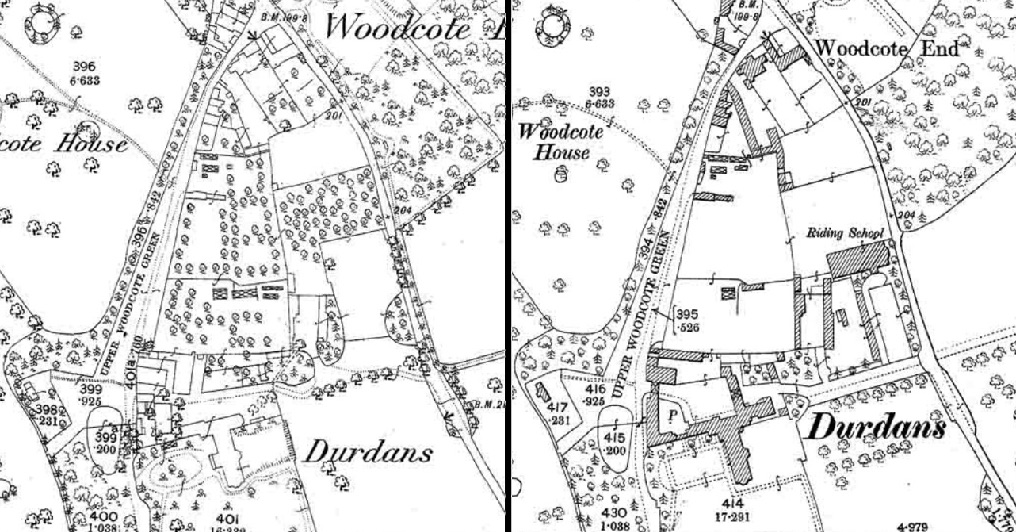 Extracts from Ordnance Survey maps showing
detailed views of The Durdans in 1866 (left) and 1896 (right).
(As conventional, North is at the top.)
(Click to enlarge.)
Although there was some access to The Durdans from Chalk Lane in 1866, it is clear that the main entrance was from Woodcote End, to an oval driveway immediately in front of the house. By the time of the 1896 map, that western entrance has been closed and a new one created just to its north. The fact that this entrance was commissioned by Lord Rosebery is underlined by his monogram over the gateway.
 The entrance to The Durdans from Woodcote End, over which
(as enlarged in the inset) is Lord Rosebery’s monogram and the date 1878.
Photographs by Roger Morgan © 2021
That gateway led into a new courtyard, as shown in the following drone shot.
 The Durdans from the North West, showing the entrance from Woodcote End.
Photograph by Andreas von Einsiedel © 2023
As can be seen from that aerial view, there is an archway on the other side of the new courtyard – of which more in due course.
It is understood that The Durdans’ previous entrance on the west here was where the “Chandos Gates” had been installed in about 1750. Lord Rosebery had those gates moved to their now familiar place on Chalk Lane, presumably to create a focal point in the view from the house looking down the avenue of lime trees created for Lord Rosebery.
 The Durdans as seen from Chalk Lane.
Photograph by Roger Morgan © 2023
(This was never a practical entrance to The Durdans, so the story about Lord Rosebery waving his son, Neil Primrose, off to the Great War – in which he was killed in 1917 – with the promise that they would not be opened again until his return, while charming, must be apocryphal.)
One of the attractions (if not the main one) of The Durdans for Lord Rosebery – a horse-racing enthusiast – was its proximity to Epsom Racecourse. The Durdans already had a strong racing connection: a previous owner, Gilbert Heathcote, was the owner of Amato, the first Derby winner (in 1838) to be born and trained in Epsom. In 1881, to realise his ambition of establishing a stud, Lord Rosebery commissioned the eminent Victorian “Arts and Crafts” architect, George Devey, to design an indoor riding school. (The buildings can be seen in the upper right of the 1896 map.) Along with other new stable boxes, the result was regarded as being among the finest stud facilities in the country. All this paid dividends in Lord Rosebery’s winning the Derby three times – with Ladas II in 1894, Sir Visto in 1895 and Cicero in 1905. (The stables and riding school are now separate from The Durdans.)
I turn now to wider 1856 and 1896 views of the Durdans and part of its then estate which was bounded by Ashley Road on the east – as seen across the upper right corner in each of the following maps. (The estate also extended south – and off these maps – up to the Downs.)
 Extracts from Ordnance Survey maps showing
wider views of The Durdans estate in 1866 (left) and 1896 (right).
(Click to enlarge.)
A point of interest from the 1896 map is that the avenue of lime trees from the house down to the Chandos Gates continued (as it does today) on the other side of Chalk Lane.
Most interesting, however, is the Lodge on Ashley Road in the top right corner of the 1896 map. When I first came to Epsom, I assumed this was the lodge for the nearby Woodcote Grove which fronts onto Chalk Lane. As shown on the 1896 map, however, it is the then newish lodge for The Durdans. The connection with Lord Rosebery is underlined by the entrance being called the “LADAS GATE” – Ladas II having been Lord Rosebery’s first Derby winner.
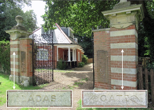 The Durdans Lodge on Ashley Road, with detail of the Ladas Gate carvings.
Photographs by Roger Morgan © 2023
As can be seen from the map, the driveway took a curved path (skirting the mound known as Mount Diston) which, after some 550 yards (500 m) reached Chalk Lane.
 Part of the driveway (viewed from Chalk Lane) from The Durdans Lodge on Ashley Road which, thanks to Mount Diston, is out of sight on the far left.
Photograph by Roger Morgan © 2023
In the photograph above, the driveway skirted the trees in the distance and then those on the right – the latter being a continuation of the avenue of lime trees mentioned above.
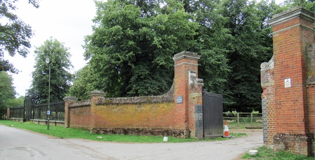 Chalk Lane showing, in the foreground, the gateway for the driveway to continue into the home grounds of The Durdans (now the entry to the Stables and Riding School) – and, on the far left, the Chandos Gates.
Photograph by Roger Morgan © 2023
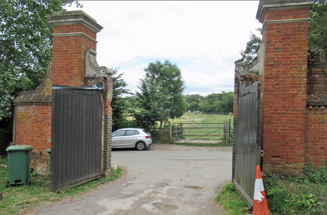
View through the gateway across Chalk Lane to the driveway from the lodge on Ashley Road.
Photograph by Roger Morgan © 2023
Visitors then had another 200 yard (170 m) slight climb to reach the new courtyard through the “other” archway (see below) created – as mentioned above – to match Lord Rosebery’s new entrance from Woodcote End.
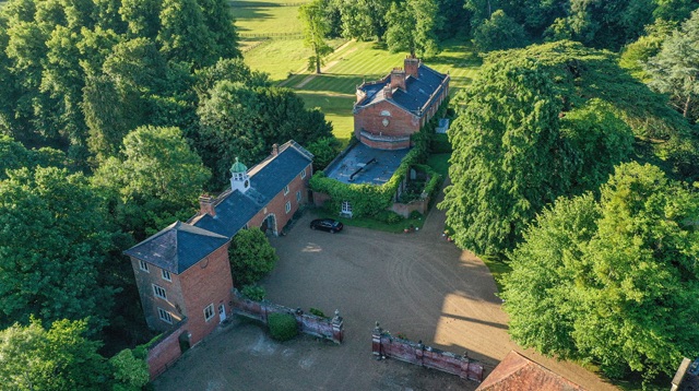 The archway at the end of the getting on for half-mile drive from the lodge on Ashley Road.
Photograph by Andreas von Einsiedel © 2023
All this is nicely brought together in the following bird’s eye view of The Durdans among the many aerial photographs commissioned by the Epsom Civic Society in 2008.
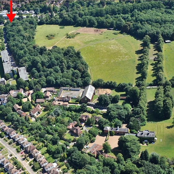 The Durdans from the air in 2008.
(The arrow marks the site of the Lodge on Ashley Road.)
Photograph with thanks to the Epsom Civic Society.
This photograph was taken from the west, and Ashley Road runs across its top. The Durdans Lodge is hidden by the trees top left, as arrowed. Although the old driveway is now grassed over, residual subsoil changes mean that its curving path round Mount Diston to Chalk Lane (which runs across the middle of the photograph) can still just be seen. In the centre is the distinctive Riding School and associated stables.
The Durdans proper is in the lower right, and the picture shows the good view that residents have down the avenue of lime trees, with the “Chandos Gates” proving a focal point before it continues on the other side of Chalk Lane. Just to the left of The Durdans is Lord Rosebery’s new courtyard with the archway through which carriages would arrive after their nearly half mile journey from the lodge on Ashley Road. Bottom centre is the entrance archway from Woodcote End which runs diagonally up to the centre left.
Roger Morgan © 2023