
The now-lost
FARM GARAGE
28 Church Street, Epsom
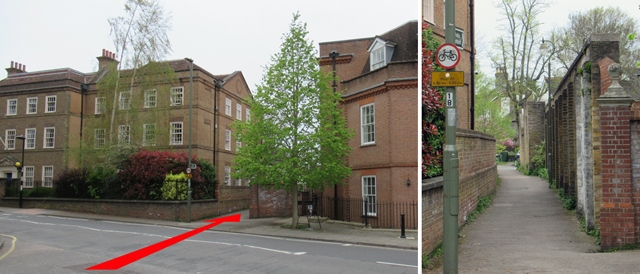 The footpath (arrowed left and detail right) from Church Street to Downside & St Martin’s Avenue.
Photographs by Roger Morgan © 2023
The photographs above show the short footpath that runs from Church Street to Downside & St Martin’s Avenue. On the left of the path is the grand Grade II* listed Ebbisham House (the central section of which – as seen on the very left above – dates from the early 1700s). On the right of the left-hand image is the much more recent but pseudo-period Charles Stuart House.
The boundary walls on each side of the footpath are oddly different. While the one flanking Ebbisham House is a plain 6 ft brick wall, the one alongside Charles Stuart House is not only rather higher but also has an oddly industrial appearance. That “industrial appearance” is shown more clearly in the photographs below.
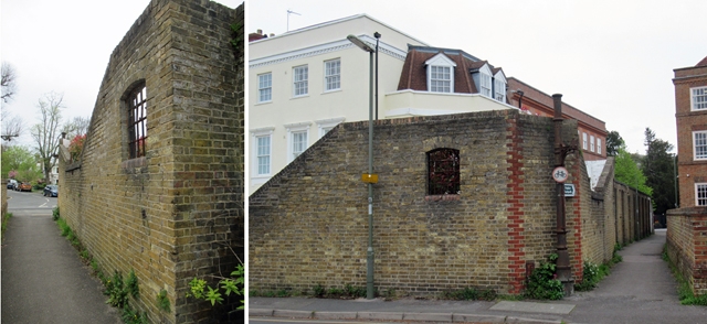 The oddly “industrial” wall alongside Charles Stuart House.
Left, from about half way along; and
Right, looking back from the Downside & St Martin’s Avenue end.
Photographs by Roger Morgan © 2023
I often use this footpath, and the urge to discover the background here quickly became irresistible. The answer – which will surprise anyone who (like me) didn’t know Epsom before the mid 1980s – is that the generally up-market Church Street was, for much of the mid-20th Century, home to a thriving car dealership and service station called Farm Garage, as pictured below. (Indeed, until the early 1920s, there was a brewery just across the road from this site.)

Farm Garage, probably in the early 1950s.
Photograph from the writer’s collection.
The “industrial” wall which sparked this article is the remains of the flank walls of the workshop shown on the left of that photograph, and of some outbuildings behind it. The garage also used the building in the the centre of the picture, which began life in the 17th century as stable block (of which more below). Visible on the far right is the side wall of Ye Olde Kings Head pub which continues today.
The following extract from the 1932 Ordnance Survey map will help orientate things.

Extract from the 1932 OS map.
The red arrows point to the footpath that provoked this article;
the Farm Garage building are coloured red; and
Ye Olde Kings Head is coloured green.
And it is useful also to have the following aerial view, in the foreground of which are the main buildings in the map above, viewed from above the map’s bottom right hand corner.
 Aerial view in 1928, a year after The Farm Garage opened.
Photograph with thanks to Britain from Above.
Just below left of centre in this aerial shot is St Martin’s church, seen here with its spire that was dismantled in 1947 following storm damage. Below that, to the right, is the grand Pitt Place (which, despite being under a preservation order, was bulldozed in 1967). Across Church Street (which runs diagonally up from the bottom left hand corner here) from Pitt Place is the roof of the Farm Garage workshop, just beyond which is the old stable block with its distinctive dormers – of which we have another view, as below.
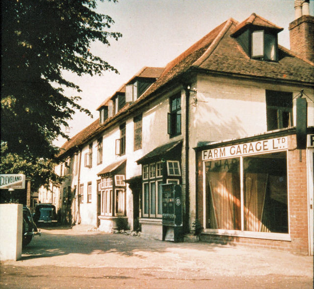 Part of Farm Garage in the 1950s – originally a late 17th-century stable block.
Photograph courtesy of Bourne Hall Museum
The early days of this site are set out in our article about the “New Stables“, and that includes the earliest pictures – painted in 1831 – of the stable block, as below. While the following century and more saw a number of modifications, the little dormer windows were unchanged.
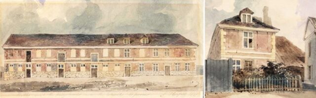
Stables beside the King’s Head, near the church, Epsom by Edward Hassell 1831
Images courtesy of Bourne Hall Museum
The stables (and the yard in front of them) had long been used as a base for training racehorses. In the late 1890s, the premises were acquired by John Francis Coleman, a veterinary surgeon with particular expertise in racehorses. He was of sufficient standing to merit an article about his work in the 7 June 1907 edition of The Illustrated Sporting & Dramatic News – see “A visit to the Farm Veterinary Stables, Epsom“. A composite image from that article is reproduced below, in which the picture in the top left (of “The covered yard”) is of particular interest: the footprint of this, which is seen in the 1913 OS map, is identical to that of the Farm Garage’s main workshop (as highlighted in the 1932 OS map above) and, except for some necessary reconfiguration, it would seem that the new Farm Garage had a ready-made workshop.
 A composite image from the 1907 article mentioned above, showing
1. The covered yard. 2. Mr Coleman outside his house “The Farm”
3. Some of the tackle used by Mr Coleman 4. Firing Cherry Ripe
(Click image to enlarge)
The picture top right in the composite is also of interest. It is a view across the front of the old stable block (here covered in some creeper) looking out to Church Street – across which can be seen Pitt Place and, beyond that, the spire of St Martin’s church.
Mr Coleman died on 8 June 1923, aged 61, having (as mentioned in The Times obituary) been called from his sick bed to attend on Town Guard, the favourite for the Derby – which, notwithstanding his ministrations, was sadly unplaced. Mr Coleman was buried in Epsom Cemetery, 12 June 1923. After brief interim usage by racehorse trainer Stuart Hyde, 1927 saw the site taken over by the newly-incorporated Farm Garage – dealing with a different form of horsepower.
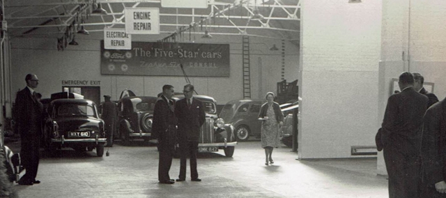


Three 1950s images inside the Farm Garage workshop.
Photographs courtesy Bourne Hall Museum.
The business clearly prospered and, in the late 1960s, the premises were enlarged. The old stable block was demolished and new showroom, offices and further workshop space was built.
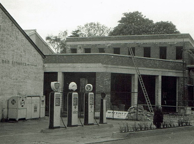
Work in progress on the late 1960s upgrade of the Farm Garage premises.
Photograph courtesy Bourne Hall Museum.
By 1971, the Farm Garage was house in a smart new suite of premises, details of which can be seen by clicking the thumbnails below.
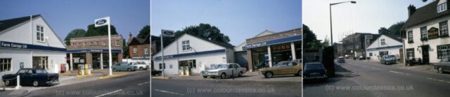 Click the thumbnails above to access the full size © colourclassics.co.uk images.
Sadly, things did not work out that well and the next two images are understood to show the Farm Garage in decline in the late 1970s.
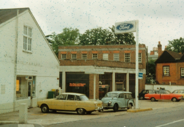
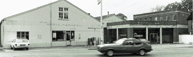 Late 1970s images of the Farm Garage in decline.
Photograph courtesy Bourne Hall Museum.
The Fram Garage closed in about 1980. In due course, the premises were demolished – leaving only the flank wall (which, as shown above, has its origins in Mr Coleman’s early 1900s “covered yard” for his horses) – and redeveloped with today’s Charles Stuart House. I sign all this off with the “then and now” pictures below.
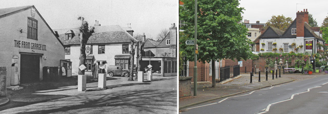 Left: The Farm Garage in the early 1950s – photograph from the writer’s collection.
Right: An up to date view from about the same point – photograph by Roger Morgan © 2022
Roger Morgan © 2023