
The Topography of Ewell
An Extract from:
The Register or Memorial of Ewell, Surrey (1913)
By
Cecil Deedes (Editor) ; Colin Ford; William Hudson; Margaret H Glyn
THE TOPOGRAPHY OF EWELL.
By Margaret H. Glyn
It is remarkable that there exist two early Surveys of Ewell : the Memorial of 1408, contained in the present volume, and the Survey of Ewell Parish, taken in 1577 by Thomas Taylor, then Surveyor of the County of Surrey. From the topographical point of view these two Surveys, notwithstanding their very diverse literary characters—the one written in mediaeval Latin, the other in the Elizabethan vernacular—are so much the complement of one another that it is scarcely possible to understand either without a study of both documents. The later Survey has the advantage of a clear and consistent description of the “town,” whereas the Memorial has the best indication of the relative positions of the ” furlongs ” into which the lands of the parish were divided.
 The 1408 Plan (Click to enlarge)
(NOTE this plan was drawn circa. 1913 and only gives a rough idea of the layout of Ewell)
I had hoped to have drawn both the accompanying plans from the Memorial, but in the case of the “vill” this proved impossible, It will be seen in the text that no acreage is given, and when the starting-point described is uncertain, and the reader is also groping after his direction, “and then next ” becomes but a vain repetition. Therefore I have had to substitute the Ewell of 1577. This plan gives the names of the householders of Ewell and the approximate outlines of their tenements. In a few cases where the name of the house was mentioned it is also inserted. The plan of Ewell parish shows the probable outlines of the furlongs as given in the Memorial, together with those of the old roads. It will be seen that these furlongs are not always of the exact furlong width—in some cases considerably wider—and while the agricultural furlong may have averaged its correct width, the woods evidently supplied an uncertain factor. There is no reason to suppose that the acreage recorded is incorrect, but its exact distribution is in many cases a matter of conjecture. Hence it must be understood that neither of these plans is to be taken as a map in any modern sense. Not even in Taylor’s Survey do the necessary materials for a map exist, for the amount of frontage of each house on the street is not given, and in several cases the roads have since been altered. An approximation is all therefore that can be presented, and the object is to assist readers in grasping the outlines of early Ewell and its outlying lands with as much accuracy as may be possible under the circumstances.
It will be desirable to point out first the links that unite us with the Ewell of 1408. The only authentic building which still remains is the tower of the old church, and the old churchyard is one of the few certain landmarks. Another is ” four-cross-road of the vill “, where stood Ewell Cross at the present junction of Church Street, West Street, and High Street. By 1577 the cross was gone and replaced by the Townhouse ;1 now only the four-cross-road remains. Certain features of the outlying country are also distinguishable. There is ” the high hill called Northulle , i.e., north hill, on the London Road ; and the South hill, also called the Easthill, now a grass slope overlooking Ewell Castle, in 1408 a cultivated furlong. Ballardsputte, i.e., pit, seems to be the one under the hill, in the Nonsuch property, the present site of a distillery, and the “pit at the southern head of the vill” yet remains in the grounds of Ewell Grove. But the two large chalk pits on the opposite side of the Cheam Road were seemingly not then dug, as they are not mentioned, and the sites were occupied by tenements and cultivated land. Amongst the furlongs of the Southfield, Priesthulle or Priesthill, and Longdown are familiar terms, and Taylesheld, later corrupted into Tayleshill. Howell (hill) in the parish of Codyngton is also given.
 The 1577 Plan (Click to enlarge)
(NOTE this plan was drawn circa. 1913 and only gives a rough idea of the layout of Ewell)
It seems unfortunate that the chief natural feature of Ewell, the river, is but once casually mentioned. It is only by means of Taylor’s Survey that we can identify CakeEwell as the spring at the river-head. The mills on the river of Ewell are mentioned in Domesday, and an interesting old house is that by the lower mill, referred to in the Memorial as ” a water-mill …. which Thomas Hayton holds, with a large closed garden attached to the same on the king’s highway leading from Ewelle to the Court of Ewelle, called the Worthe Courte.” A part of this house is considered to date back to the fifteenth century. The garden has become meadow land, which still forms part of the property. The king’s highway is now a lane which soon dwindles to a footpath, the fate of most of the old roads in this neighbourhood. But it still leads to the ” Worthe Courte,” the manor of Ewell, described on p. 158 of the Memorial. This manor-house, with its garden, watermill, etc., has long since vanished, and only an ordinary farm remains, standing on rising ground a little above the river, but since it is known as Ewell Court Farm and belongs to the Lord of the Manor of Ewell, it is clearly the site of the Worthe Court.
“The Rectory of Ewell” stood on the site of the present rectory. In 1577 this house is thus described “Nicolas Saunders (the chief landowner in the place) holdeth freely the P’sonage house of Ewell, with a barne. Stable, Hayhouse, a Yard of the backside with a little close or Lane adjoining.” It is probable that this lane is identical with the Parsons-lane of 1408, which seems to have run parallel with Church Street, coming out into the present High Street, not far from the corner. By 1577 it had ceased apparently to have any opening into High Street, and its name had been transferred to the rectory, which house was then known as the Parsonage house. At the same time there was a Parsonage Lane in another place altogether, the lane now leading from the London Road to the present playing-field. In 1577 this lane led straight through to the Kingston Road, and came out near the lower mill ; upon the east side of it lay Church lands, from which doubtless it took its name.
In 1408 there was no Vicarage house, and Ewell had never had a permanent Vicar. After the appropriation to Newark Convent in 1416 another forty years was allowed to elapse, and at last, in 1458, took place the endowment of a perpetual Vicar, Thomas Hardyng being the first representative. A translation of the original deed, given by Manning and Bray, states that a Vicarage, said to consist of manse and garden, was then already in existence : ” the said manse, the aforesaid Prior and Convent, within one year from the date of these presents to be computed, shall build up & repair, viz., an Hall, & at one end thereof, a Parlour with a Chamber over the same ; & at the other end a Kitchen.” This is the type of the original Saxon house, in which the chief feature was the lofty hall, with a hearth in the centre and rooms opening off at each end. The Worthe Court was similar, and several others are mentioned. It seems probable that in the fifteenth century this was still the usual type for houses of any importance. The site of the Vicarage in 1577 was on the south side of Church Street, not far from Ox Lane, which was known in 1408 as Osemond’s Lane.
The Hermitage was probably a single cell standing in a clearing of the Rector’s firwood, which must have been on the south hill, near to the Codyngton boundary. The outlying parts of the parish still exhibit the same general features that are described in 1408, arable land on the south extending to the downs, and grass land on the north, the only difference being the disappearance of the woods and copses, the enclosure of the commons, and the addition of some arable farm land in the northern part of the parish. The reason for the general features and their persistence lies in the nature of the soil. Across the centre of Ewell the chalk of the higher ground meets the clay of the lower lands ; here the springs rise and form the river which drains the northern district and receives little streams which wander through the fields, half hidden under boundary hedges. This heavy clay soil is better suited for pasture than arable land.
In the Memorial the whole of the northern portion of the parish is included under the term “Common of Ewell”. The word Common did not then apply necessarily to unenclosed spaces, but rather to the manner in which the lands were held. Thus the enclosed meadow called Cherlemannes mede is also mentioned as a Common. The account of this part of the parish is somewhat fragmentary, in contrast to the Southfield, the district south of Ewell, which is fully described with the names and positions of all its furlongs. In the north there are but twelve furlongs mentioned, with a total of about 160 acres, and two or three of these, Heghcroft, Stanecroft, etc., appear to have been in the adjoining parish of Codyngton. The two parishes lie side by side, being, roughly speaking, each about four miles long and a mile broad. The Northfield, mentioned several times, was not, as one might suppose, the northern part of Ewell parish, but of Codyngton. At this time a considerable part of the lands of Ewell Manor lay in Codyngton parish, the Greatworthfield, Sparewefield, Oldelonds, the roll Buttes, and others. In the Codyngton part of the Survey some of these same names appear, notably the Common of Sparfield, which is known as Sparrow Farm to this day. The survival of this old name is the more remarkable because, in the sixteenth century, practically the whole of Codyngton parish, together with a slice of Ewell, disappeared into the Nonsuch Parks created by Henry VIII. This event took place between the early and the later Surveys of Ewell, so that in the Memorial we have the pre-Nonsuch condition of the country, and in the Elizabethan Survey evidence of the changes caused by the enclosure of these parks. The town of Codyngton was entirely wiped out, whereas Ewell was only affected by alteration of the roads and the loss of manor lands and certain parts of open common. The Greatworthfield of 212 acres disappears from the later Survey, and the chief demesne lands of Ewell Manor are the Worthfield, which has lost nine acres, the Oxleas (Oxenlese), Kingsmead by the river, the “piece of land at Shaldefordfield ” of 18 acres, (described by Taylor as Priorsfield), and the two small crofts next mentioned, one of which is called Salmond in 1577 (doubtless the same name as Alemannes and Salemannes). The remaining manor lands lie near the village or in the Southfield, but the names Frelandsherne and Retherwekemede have disappeared, and these sites cannot be traced.
The Common of Ewell in 1408 must have been over 1000 acres, larger indeed than the Southfield, being nearly as long and a mile and a half wide at the extreme northern end. The furlongs and demesne lands of the manor account for only about 260 acres, leaving apparently 800 or so as open common. At the same time the old manor of Shaldeford, dating back to the thirteenth century, the name of which was, about 1460, changed to Rokesley, is unaccountably omitted from the Memorial. In 1577 these manor lands on the north of Ewell contained at least 120 acres, and the Lord of Rokesley also possessed land in the village. The old manor house of Shaldeford stood on the left bank of the river, just beyond the present Ruxley Farm, close to the ford from which it took its name. There is still a deep ford here, and there is every reason to suppose that the lane which crosses it, now connecting the Chessington and Kingston roads, is the same as in 1408. It is then mentioned as the “way called Alemannescroft “, and in 1577 it is described as the lane leading from the West Heath to the East Heath Common, and the position of these commons was at either end of the present lane. Curiously enough, Shaldeford field, south of the lane, belonged to the manor of Fitznell, and this seems to show that the ford was there before the manor of Shaldeford, in which case the old lane was probably there also from a very early period. All along the river banks from Ewell were enclosed meads, and the Shaldeford or Eokesley lands lay at tlie extremity of the parish. East and west of the meads were open commons, all of which are now enclosed fields. In 1577 three separate commons are described, the Marsh Common (the site of West Ewell), 28 acres; the West Heath Common further north, 24 acres; and the East Heath Common of 120 acres. The latter common was crossed by the Kingston road, but at that time about 200 acres of its former extent had gone into Nonsuch Great Park. It is probable that in the fifteenth century the Marsh and West Heath Commons were not divided by enclosed land, since none is mentioned in 1408, but formed one large common corresponding to the East Heath. The total area of these unenclosed lands cannot have been less than 650 acres as against 172 acres in 1577, showing that enclosure had begun to take place at this early date.
It is remarkable that, with the exception of the crossroads in the centre of Ewell and the old lane already mentioned, scarcely a road of 1408 still remains in use as a road, although, as has been observed, several have become footpaths. The Nonsuch Parks blotted out not only the church and town of Codyngton, but also most of the roads leading to it. Codyngton was once thought to be only a hamlet, such as were Epsom and Cheam at that time, and Ewell, the market town, appeared to be the principal place on this side of Kingston. Such it had become in the latter half of the sixteenth century, but this must have been largely by reason of the disappearance of its rival. For Codyngton was a centre whither led six high roads, from Cheam, Merton, Ewell, Walton-on-the-hill, Letherhead, and Kingston via Talworth. The Cheam and Merton roads cannot be identified from this Survey, but the four others cross Ewell parish.
One of these, the highway between Ewell and Codyngton, started from Ewell Cross, and was called East Street. It followed the present Church Street, but instead of turning north by the churchyard it held straight on up the line of Vicarage Lane till it reached the Codyngton boundary. Beyond this it is not mentioned, and the exact site of Codyngton is uncertain, but its outskirts may have begun at this end of the Nonsuch Avenue. Anyone going to London from Ewell must have passed through Codyngton and so to Merton, for the present London road did not then exist. The first mention of it is made in the Elizabethan Survey as ” the Greenway which is the highway between London and Ewell and between both the Pks of Nonsuch at the gate there called the Heygate.”2 In the accompanying plan of Ewell parish the park pale of Nonsuch is marked by a single dotted line, and a glance at this will show that it was necessary to make a new road in order to provide egress from Ewell on the London side, since East Street would have led almost up to the site of the Palace. The new road was thus made to connect with East Street at the Ewell churchyard corner, and until about eighty years ago it was the only way through the place from London.
A second road led from Codyngton to Kingston via Talworth, and is called Codyngton Street. As far north as Maiden the whole of it disappeared into Nonsuch Great Park, but beyond Maiden a footpath and further on a lane still lead to Talworth, and would seem to be the old Codyngton Street. This side of Maiden the road formed practically the boundary of Ewell parish on the east, and thus it followed the same line as the present footpath to Worcester Park. It seems probable that the old roads were used as ways within the parks, and when finally these were broken up and sold off to various owners the roads still persisted as cart-tracks and footpaths. Codyngton Street, it will be seen, turned off northwards from East Street, and on the Ewell side of this road, on the north hill, dwelt Lawrence Codyngton, for those Ewell days a large landowner, and several others, also landowners, since their tenements abutted on “lands belonging to the said tenements towards the west”. Besides the connection with East Street, Codyngton Street could also be reached from Ewell by another of the “four cross” roads. This was Middle Street (now High Street), which led out apparently then, as now, beside the river, where it became the Kingston road. Here it lee through a ford caused by springs on the east side which flowed across the road into the river, there being stepping stones for foot passengers. When, about 1830, the connection with the London road was made, a large drain was laid under the road, thus removing the ford. ‘From the point by the lower mill, where the Kingston road leave: the river, it was called the Stetegrene , and is described as bounding Stete and Shortcroft furlongs, where presumably it joined Codyngton Street The present Kingston road does not appear in the Memorial after it leaves the river, and evidently it was also a creation of the Nonsuch period to replace the vanished Codyngtoi Street. In Taylor’s Survey the further portion of it is called Talworth Lane, and appears to have windings, but r is more or less on the line of the present road, which then as already mentioned, crossed the East Heath Common.
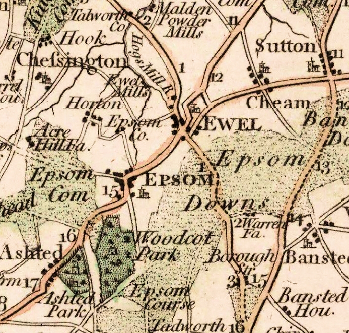 Cary English Atlas 1787
The two remaining Codyngton roads, those to Letherhead and Walton-on-the-hill, leave Ewell on the south. The former is called the Portwey, and is mentioned ai bounding several furlongs immediately to the south of Ewell.3 This road is now represented by the footpath (Cary’s English Atlas of 1787 marked as a road) which lead; from Nonsuch avenue across the fields into the Cheam roa( and then by the lane known as Monger’s Lane. Beyond this in 1408 it bounded several more furlongs in a westerly direction, and after crossing Epsom and Ashtead parishes; or near the line of the L.S.W. Railway would most likely have entered Letherhead by joining the high-road from Kingston. The present road from Ewell to Epsom was no made, and probably its continuation to Letherhead is also of later date than the Memorial, whereas there must have been a Kingston and Letherhead road from early times. In a large chalk pit near the Portwey, close to Ewell, six Roman pits or dene-holes were opened in 1847, and two more were discovered in 1860. These contained (besides animal bones, oyster and snail shells, and mould in layers) Roman potsherds and vases of Samian ware, fibulæ, a thin bronze armlet, a number of coins, an iron rod and hammer, and two oak stakes, all of which are now ifn the British Museum. It is quite possible that the Portwey may be an unrecorded Roman road, and that Ewell was the site of an ancient British settlement, but this Portwey has nothing to do with the Roman road of that name which ran to Salisbury, nor with the Stane Street from Chichester to London, which is supposed to have come through Ewell. No certain trace of the latter is found this side of Mickleham, and it seems more likely that the Stane Street crossed the Downs in the direction of Carshalton and Streatham, leaving Ewell on the west. It is quite clear from the Memorial that there was then no road crossing Ewell on the line of the supposed Stane Street ; the London and Epsom roads, which have been thought to represent it, are of later date.
The fourth old Codyngton road, to Walton-on-the-hill, seems to have turned off from the Portwey at the Ewell boundary and was called at first the road to Ballardspit. The Walton road must necessarily have passed Ballardspit, and doubtless there was but the one road thither. Turning south-west it joined the old road to Burgh, following this south-east until it turned again westward on the line of the bridle-path that meets the present Reigate road nearly a mile out of Ewell. Beyond the Ewell boundary it must have gone somewhat south in order to cross the Downs to the Grand Stand. From the hill opposite the stand a footpath leads to Walton, and one may assume this to be the line of the old road.
Returning to the ” four-cross road ” of Ewell, we find West Street in 1408 as now, and South Street on the line of the present Cheam road as far as the ” pit at the southern head of the vill ” already mentioned. Here in 1468 stood another cross known as Provest Cross (probably named from Provys tenement), at which, according to ancient custom, it was the duty of the Vicar to meet the funeral processions from Kingswood and conduct them thence to Ewell Churchyard. There was then neither a Cheam nor a Banstead road in existence, and the one that led out past Provest Cross was the old road to Burgh or Burrow Heath on the way to Reigate. It is interesting to find that this old road followed the present farm-track as far as the top of Priesthill. Here the track now turns eastward, but the Burgh road held straight on till it curved round to join the line of the present Reigate road at the point where the road from Epsom now comes in on this side of the Drift Bridge. Thence on to Burgh is the old road, but from Ewell up to the Drift Bridge is a modern road made scarcely more than a century ago. The first edition of Patterson’s Itinerary, 1786, and Cary’s English Atlas of 1787 both show the road to Burgh on its old line, and the reason for the shifting of the road about a furlong westward is not far to seek. By the Enclosure Act of 1801 a farm was made, stretching from the Codyngton boundary (at that point the Banstead road) westward up to the present Reigate road. This road now bounds the farm on the west for a mile or more, but the old road must have cut through the middle of it, and was doubtless shifted in order to avoid dividing the farm. A Banstead road or track was in existence in 1577, and may have led off from the old Burgh road in a different line from the present Cheam road, which now forms the lower part of it. This latter road was not made until after 1787.
It will be seen on the plan that the old Epsom road followed an entirely different course from the present one. While Epsom was merely a hamlet no one troubled about the way thither, although a direct road from London had been made as far as Ewell. But with the rise into fashion of Epsom Wells in the seventeenth century positions were reversed. Ewell lost its local importance and became the approach to Epsom, and obviously a continuation was required of the direct London road. Just beyond Ewell ” four-cross-road ” a new way was made, the present Green Man Street, which cut diagonally across the furlongs in its further course as the Epsom road. It is probable that the new thoroughfare, with its increased traffic, brought prosperity to Ewell, and that the folk ceased from the arduous task of cultivating the land when able to make money more easily in another direction. It is curious that the new Epsom road should have cut the former one almost at right angles, but the cause of this lies in the shifting of the site of Epsom. The town dates from the seventeenth century, and before that the site was open country. Epsom village lay nearer the Downs round the parish church, and therefore the original road to Epsom took a different course. It was known in 1408 as the Epsom and Kingston highway, and was crossed by the Portwey, which had previously united with what was called the Epsom road from Ewell. This part of the Portwey has disappeared, but the old Epsom and Kingston highway can be recognized in the lane that crosses the present Epsom road at the point known as the half-mile-bush, the boundary of Ewell parish, and continues southwards to Epsom Church, Until some few years ago there stood, a little to the left of this road after it crosses the L.B.S.C. Railway, a windmill, to which a lane branched off known as Windmill Lane. In 1785 this lane led on past the windmill and formed part of another lane, which now passes Longdown Farm. Doubtless the Enclosure Act caused the disappearance of this link between the windmill and Longdown, and the latter lane was bent eastward until it joined the new Reigate road at the present point of junction, thus making a direct connection with Ewell.
On the north side of the present Epsom road the lane, the old Epsom and Kingston highway, soon becomes a foot-path, which ceases at the modern hamlet of Gibraltar. Here it meets the road from Ewell known as West Street, but the upper end was then called Gallows4 Lane. In the angle formed by Gallows Lane and the continuation of the old road to Kingston lay Lymecroft field, the largest of the northern furlongs. Lymecroft was bounded on the north by Roberd Street, which is the beginning of the present Chessington road that now meets the Kingston road in Ewell by the horsepond. As late as 1785 there was a second ford here, the river running between these two roads; the present road-bridge was made at the close of the eighteenth century by the family to whom the mills still belong. Thus Roberd Street did not cross the river, but starting on the left bank it led on past Fitznell’s and the lane adjoining it leading to Cherlemannes mede, then known as Fitznell’s Lane and later as Northcroft Lane, after which it passed by various tofts and tenements, most of which belonged to Laurence Codyngton. Probably it crossed the site of the L.S.W. Railway station, and joined the grass lane which comes out into the Chessington road a little further on. This road now forms the boundary of Ewell parish on the west, and it can scarcely have been other than the old Epsom and Kingston road in 1408, the intermediate piece between Gibraltar and the grass lane being now missing. It may have gone to Talworth by the Ruxley lane or by the footpath from Bonesgate, or possibly via Hook to Kingston.
The ” description of the vill ” given in the Memorial may “be summarized in a general way as follows : –
The first Bound describes the houses upon the Kingston road, beginning near Beggars Hill. Teppes Lane seems to coincide with Mill Lane, and Austynes Lane with the lane that led from the old church to the Spring Hotel before the present church was built.
The second Bound given consists of a block of houses lying between the Parsons Lane and Church Street, and bounded east and west by the Rectory and High Street respectively, adjoining the Bound previously given. After this we pass to Codyngton Street.
The third Bound contains the houses on the west of Codyngton Street from East Street going north probably as far as the end of the Shortcroft furlong. It may have included also a toft and a croft of half an acre called Little Garewell on the east side of Codyngton Street.
The fourth Bound describes the south side of Church Street from the church down to the Cross and round the corner up the east side of South Street as far as the pit previously mentioned.
The fifth Bound includes all the houses on the west side of South Street down to the Cross, and leads round into West Street (south side) about as far as the top of the hill now called Mount Pleasant.
The sixth Bound begins on the north side of “West Street (upper end) and goes down to the Cross and round into Middle Street (the present High Street) and. then returns up Spring Street, which is here unnamed.5 It may have been part of Middle Street, but at the further corner we find Whyte’s Lane running north into Roberd Street as Spring Street does now.
The seventh Bound lies on the north side of Roberd Street, beginning perhaps near the L.S.W. Railway station, passing eastwards to Fitznells, and so round probably to the left bank of the river and northwards by the lower mill.
The eighth Bound begins near the spring at the river-head and seems to go all round the property which is now known as Garbrand Hall. The tenements Quedekepes and Heverenorthes are mentioned as lying on the west of the river-head, and they are reached again at the conclusion of the Bound, showing that a complete circuit has been made. This being so, the houses would face first east on to a way beside the river, then north on to Roberd Street, then west on to Whyte’s Lane, and finally south on to Spring Street. By 1577 the houses facing east on to the river had been replaced by a “Mansion House.” Between this and the river on the east lay ” a Psell of the Waste ground or river of Ewell lately inclosed with a stone Wall, and within the same a little banquetting House late erected and Ponds and fish therein within the same enclosure” (Taylor’s Survey). A marginal note adds that this enclosure had been made about thirty years previously by several of the inhabitants and tenants of Ewell (presumably as a public enclosure), but in 1577 it belonged to Nicolas Saunders, the owner of the mansion. This enclosure occupied half a rood, and must have been the beginning of the ornamental water in the grounds of Garbrand Hall.
In 1408 there were 111 houses in Ewell, and if the word toft is intended to signify a plot of ground where a house formerly stood, there must have been, evidently before the Black Death, 166 houses, since 55 tofts are mentioned scattered here and there, or in groups together, all over the village. About 76 of these tenants of the houses held land in the Common Field. In 1577 there were but 66 houses in Ewell, besides a few outlying cottages, and only 42 tenants of land, one or two being fairly large holders, and the land was still in cultivation. Between 1577 and 1801 the tenants had ceased to cultivate, the furlongs were ” handed over to oblivion,” and the owners had so entirely neglected their rights that the Southfield lapsed into common down. In Cary’s English Atlas down-land coloured green extends almost to the outskirts of the village. The Commons Enclosure Act of 1801 gave the land into the hands of the leading residents in order that it might be cultivated, on account of the shortage of wheat caused by the war. The Surveys reveal that this cultivation was not in the case of the Southfield a new departure, but an agricultural renewal.
A comparison of the two Surveys brings to light some curious examples of name corruption. In 1577 the spring of the river is named KattEwell, obviously derived from the CakeEwell of 1408, which in its turn was no doubt corrupted from some earlier source; possibly the original name was St. Catherine’s Well. Another instance is found in “the Common called Cherlemannes mede”, which in. 1577 is thus described: “The Churchwardens of Ewell hold to the use of the Parish the common mead called Charman mead.” In recent times this field was known as Chamber Mead. It may also he mentioned that between 1408 and 1577 Clotydene furlong has become Clodend, Butine changes to Bitten, Ruden appears as Ridonhedge, and Drytgrave degenerates into the singular title of Dirty Grove.
As a general rule house-names had no permanency. Houses were called after their occupiers (a custom not entirely extinct in Ewell), and when a new tenant came in the former house-name held on for a generation or more until the newcomer had established himself and his name in the place, when the house began to be called after him and the old name passed out of use. For instance; we find ” Caddes tenement, formerly of Richard Cadde, which Thomas Joyner holds “; again, ” a messuage with a garden called Clerkes, anciently Mayhewes, which Margery, daughter of Thomas Clerke, holds,” and so forth. Frequently these house-names occur as tenants’ names in the Custumal a century or so earlier. If a tenement bordered on a lane, that lane was likely to be known by the name of the tenant, such as Carter’s Lane, Whyte’s Lane, etc., so these names also changed. Thus it happens that of ten lanes mentioned in 1408 not one appears under the same name in 1577, and of all the house-names of the Memorial there are only six in Taylor’s Survey: Ferebras in “West Street, Tabards in Church Street, Fitzneeles altered to Fennells by the river, Wastelys altered to Wastell near the Spring Hotel, Ballardes on the site of the present Church, and Botayles altered to Buttall opposite the spring. The last three site-names have shifted somewhat, but the new sites are near the original ones. Of these houses Fitznell’s is the only one still existing, parts of which are undoubtedly Elizabethan and may date back earlier. The name, it will be observed, has reverted to its original type.
Margaret H. Glyn
Notes
1 Here in the street is situate and standing a house late builded which is called the town-house, not lett, but for the use of the Town only” (Taylor’s Survey 1577). “There was a few years ago a small market-house standing at the intersection of the roads to London and Kingston, which was removed to widen the road for the accommodation of passengers” (Manning and Bray, 1804).
2 So named doubtless from Haye, Heymede, and Heyoroft or Heghcroft, manor lands enclosed in the Parks (pp. 163-4).
3 This road did not enter the village, but on pp. 58 and 60 it is described 8 leading to Ewell. It is clear that on p. 60 the Portwey is intended and not East Street.
4 In 1577 the whole road down to the village was called Gallows Street, and this name continued in use until the nineteenth century, when it was re-named West Street, an unconscious reversion to the name of the fifteenth century.
5 Described in Taylor’s Survey as the “lane or highway to the Marsh Common on the “West.”
If you are interested in the local topography you may also like to see some old maps.