
The Story of the Stone House Epsom.
By Brian Fender, FRIBA, the owner of Stone House from 1959 until his death in 2014
We have another account of this property which is at 59 Church Street.
This building should not be confused with The Stone House, Woodcote Green
The Broad Picture and Copyhold Tenure:
Stone House is half of a house that was divided in 1947. It stands alongside the parish church which is one of the two churches that William the Conqueror’s Doomsday Book tells us were there. It is not known where the other church lay. There would have been dwellings close to each of them, and there was probably a house on the site of today’s Stone House when the survey was made; but it was not until Doctor Lehmann made his painstaking analysis of the Manorial Rolls of Epsom that any detailed information was obtained. These recorded all the transactions in which the manor was involved from 1663 to 1925.
At that time most land was held ‘copyhold’. The term ‘Copyhold’ means that record of title was by copy of an entry in the manorial rolls. This was a legacy from the feudal system, under which land was granted by the sovereign to nobles who gave service to the crown, and who granted land to others who assisted them in so doing. At the bottom of the pile would be citizens who held their land by grant from the manor.
The grant continued for so long as service was given in the customary form. In theory it lapsed on death but it was normal to admit a titleholder’s heir to his forebear’s holding if he was willing to continue the service. Admission usually involved the payment of a ‘heriot’ in recognition of the grant, which might take the form of the inheritor’s best beast, or perhaps a cash sum in lieu. Service might be in the form of physical labour, or the supply of goods, or payment of a ‘Quit Rent’ that acquitted the titleholder from physical service.
‘Copyhold’ title no longer exists. Sometimes land was ‘enfranchised’, and became what we now call ‘Freehold’ but this did not happen very often. Superior titleholders were not in a hurry to release their property, and the income that it brought them. Later a more sophisticated version known as Leasehold came about when large city developments were taking place. Land was leased, subject to a suitable ground rent, to a developer to build upon. The lease was usually for 99 years, and the developed property was sold at its market value, the purchaser paying the ground rent, but having the benefit of the property for the duration of the lease. When the lease expired the land and the property on it reverted to the ground landlord. Copyhold with all its complications was finally done away with in 1925. Leasehold is still with us, though now a little easier to enfranchise.
Meanwhile, reverting to Doctor Lehmann’s exercise, it had to be said that he set himself a herculean task. Entries in the Manorial Records were made in chronological order, regardless of location. There were no maps; properties were simply described in words by reference to those adjoining them. He translated the entries (which were in Latin until 1733), and classified them in a more accessible order, street by street.
Edward Lambert
The earliest record in Lehmann of the house we now know as Stone House, is in a 1680 survey that tells us that Edward Lambert, citizen and cook of London, held amongst other property: one messuage ,one barn, one stable, one garden, one orchard and half an acre of land adjoining, abutting on the church yard on the south part and the common fields on the east. The description is clear in that the church is to the south (although south east would be more accurate) and the common fields were behind, but it doesn’t tell us much about the shape or size of the property. We do however get further clues from later entries.
To start with A3 in Lehmann helps a little. It tells us that the neighbouring property to the north held by John King in 1680 …. abutted on the highway leading to the church … and the messuage of Edward Lambert on the east and south part. Why east and south? Did Lambert’s property wrap round the back of John King’s. Indeed, that is what it did; we learn more about this further on.
Robert Parker – Malting and Brewing
Entries at 8B1 and 8B2 tell us about acquisitions made in 1711 by Robert Parker, brewer, in Birding Bush Shot, to set up a malthouse. Birding Bush Shot was part of the common fields (that lay between today’s College and Albert Road). The malthouse is shown on later maps up to 1932 but is now replaced by Wimborne Close.
Another entry at 9B1 tells us that on 27 October 1714 Parker acquired all Edward Lambert’s properties in the town, including the house in Church Street, in which he started his brewing activities.
Face Lifting
Parker embarked on a major face-lifting exercise. He retained and added to the original oak frame but reorganised the internal layout; he raised ceiling heights, inserted fashionable sliding sash windows, and reorganised the roof so as to effectively conceal it behind parapet walls. Today’s Dining Room was formed from part of it; an elegant staircase was inserted in what was the rear wing ; an entrance passage and the panelled Drawing Room and Bedroom were added at the garden end. A further part, south of today’s Dining Room, was also retained, but this was later rebuilt complete with a porticoed entrance that is still there.
When the house was divided into two in 1947 our neighbours kept the porticoed entrance and our predecessors had to reopen the passage that Parker had formed. They removed the plaster. The framing on the Dining Room side, dating to perhaps 1600, was well weathered; but the newer oak framing on the other side had to be adzed to provide key for plaster.
Recent Discoveries
Immediately behind today’s Stone House is a lofty void that serves today as the garage to number 59. Wishing to reduce my heat loss thereto I sought my neighbour’s permission to strip the plaster on his side and add insulation. I did so, but also found that the oak cills below ground were completely rotten, as a result of past brewing operations. These had to be underpinned. This opening up revealed the detail of Parker’s costly adjustments to ceiling heights and roof construction that I have referred to.
Parker mortgaged two other properties in the town to pay for his improvements; and to provide further cash he then sold the copyhold title to the property itself, to William Betts, baker of Epsom; but didn’t move out.
Absentee Landlords
Sale and lease-back deals are usually thought of as a modern concept. If they are, Robert Parker was ahead of his time. He was earning enough to pay rent but needed cash to pay for his costly improvements, whilst still keeping a roof over his head.
William Betts did not hold title for very long. From 1738 the property passed through the hands of a succession of absentee landlords, starting with John Manley. In 1751 John Manley of Middle Temple obtained a 21 year licence from the manor to let:
All the messuage wherein Sarah Parker widow, now deceased, lately dwelled, with the storerooms, yards and gardens adjoining, now in the tenure of Isaac Tarrat.
I was puzzled by the reference to Sarah Parker. Parker’s wife Elianor had presumably died. Had he married again? If, as I am told, Sarah was the widow of Parker’s son, this explains her presence in the same household.
Other points on the Parker era
The malthouse in Birding Bush Shot was not included in the package passed over to William Betts. The manorial rolls tell us that on the death of the elder Robert Parker in 1741, his grandson Robert Parker was admitted to that property as his heir; but it seems that the younger Parker was not the businessman that his grandfather was; six years later he was declared bankrupt. However since Sarah was still living in the house ten years after the older Parker died, it seems that he was far-sighted enough to set up the lease-back deal on terms that left a roof over his daughter-in-law’s head as well as his own.
A later entry describes Stone House as having a walled garden. It must have been Robert Parker the elder who enclosed the garden in that form; it is consistent with the extensive improvements that he was making; and it is unlikely that any of the absentee landlords that held the property after his death would have invested in such luxury for the benefits of their tenants.
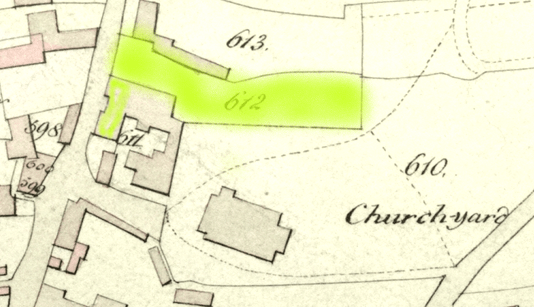 Stone House and garden – Tithe map 1838
In a 1755 survey the Manorial Rolls tell us that John Manley’s holding abutted on the holding of Sir Phillip Musgrave on the south-east part, but there is no record of a copyhold title to the south. This suggests that Sir Phillip had taken over, enfranchised and built upon the ‘church pit’ that is referred to in various earlier entries.
Other Landlords
Following the various absentee landlords the property passed to Fitzherbert of Epsom, whom the Manorial Rolls actually tells us, in another entry, lived at Pit Place. He divided the former Parker property and sold the part nearest the church to Langley Brackenbury, brewer, with its walled garden and store cellar rooms, and the part to the north to William Wheatley, carpenter. Brackenbury had presumably come as a tenant and had taken over the existing business; we know that he was a brewer because an entry concerning Parker’s former malthouse tells us this.
We have concluded that Parker, the last resident proprietor, had the walls built around his garden and, knowing that John Manley sought his 21 year licence to enable him safely to invest money in the premises, it is likely that the ‘store cellar rooms’ that Brackenbury acquired were part of that investment and were formed around 1760.
Those cellars still stand as the crypt beneath today’s Church House.
Toms Lane and the Grove
Whilst not telling us exactly where Toms Lane lay, the Manorial Rolls give detailed dimensions of a land swop took place in 1830 between John Whitmore of The Grove and Elizabeth Wheatley. The Grove was a demesne property (in the road of that name today). Whitmore wanted to close his access from Toms Lane, which was probably no more than a muddy track leading into the common fields, and form a more elegant drive to his house from Church Street. He acquired and pulled down a number of nearby properties to enable him to do this; and negotiated a land swop to straighten the boundary between his and Wheatley’s land, along which Grove Lane was to be built as a replacement route into the Common Fields. This has since been widened and is now known as Grove Road.
Elizabeth Wheatley seems to have driven a hard bargain for she gained more than she gave but it is the record of the specific dimensions of the swopped parcels that has enabled me to deduce the shape and size of the original property that Parker took over from Edward Lambert; for there are no entries to suggest that the boundaries had changed meanwhile.
The Tithe Map
In 1838 a measured survey of Epsom was made to provide for the changeover from the tithe system to the rating system. This was published after the Whitmore/Wheatley land swop, and does not therefore show the route of Toms Lane which had by then been closed; but it does show the replacement Grove Lane following a curious course at the south end, presumably brought about by a recent enlargement of the churchyard.
The Common Fields
The Common Fields belonged to the manor but were cultivated by villagers who relied on agriculture for their living or a part of it. The fields to the east of Church Street were known as the Smith Hatch Common Fields and those to the west as Woodcote Common Fields. These were divided into about 50 named ‘Shots’ which were divided again into strips allocated to individuals. Judging by the number of strips some of them must have held quite a number of these and not necessarily all together, for acquisitions and releases often occurred at random resulting in a patchwork pattern.
Other Brewer Proprietors
Brackenbury’s house and brewery then passed to: John Rutter of Epsom in 1804, William Cobbold in 1812, and finally to Trayton Peter Pagden and Stephen Pagden in 1824
Trayton Peter Pagden paid £750 for the Church Street property and two public houses in the present market square, and Stephen Pagden paid £650 for the Rummer public house ( believed to be the Amato) and adjoining messuage.
The Pagdens
Elizabeth Wheatley’s adjoining holding had been sold, following the 1830 land swop, to an Edmond Daniel of Lincoln’s Inn. It appears to be quite separate on the 1838 Tithe Map, but the first Ordnance Survey map issued 1866 shows no dividing wall between the two at the road end. The Pagdens were probably occupying that part for stabling and staff quarters; but doing so as tenants, for there is no record of any change of ownership in the manorial rolls.
In 1873 the buildings thereon were destroyed by fire, and no steps were taken to rebuild them. The burnt out house was demolished. The wall on the Pagdens’ side which supported their conservatory had to be retained, but without the other walls to buttress it was not well supported. This produced another problem which I come to further on.
Brewing uses a lot of water. This would formerly have been drawn from a well. I have found troughs in the oversite concrete beneath my kitchen floor which evidently conducted the waste water from cleaning vessels to a soakaway. This is represented by a little circle on the 1896 ordnance survey map. It was no doubt messy, and the present larger fountain was probably formed to tidy things up. In 1921 Pagdens’ Brewery was sold to Barclay Perkin & Co Ltd, and closed.
Mr Warren and the Harter Fund Trustees
In 1921 Mr Warren and others put together a series of deals whereby Pagdens’ Brewery and the brewer’s house (then known as Stoneleigh) were bought and divided between himself and the trustees acting for the church, who planned to erect a church hall in place of the brewhouse, and to enlarge the forecourt of the church to its present size. By Heads of Agreement of 23 May 1921 it was agreed, in summary, that.
Mister Warren would buy Stoneleigh for £1350.
Trustees … would acquire the brewery premises for £900 …
… Mr Warren would lend the Trustees £250 for the enlargement of the Church forecourt …
… and provisions were made regarding ancient lights.
The Trustees also had an option to buy Stoneleigh following Mr Warren’s death, which they did not take up; and ancient lights were defined so as to avoid overlooking Stoneleigh’s garden; these have so far been complied with in spirit albeit not precisely as worded.
The brewery buildings were mostly pulled down, bur Church House was built on the site of, and to the same outline as the main building, and over the store cellar rooms that Brackenbury had earlier acquired, which were left in place as a sort of crypt.
The Linfords and the Booths
In 1947 Stoneleigh was bought jointly by two couples. The Linfords took over the south end of the Pagdens house with its porticoed entrance; and kept the number 59. The Booths took over the north end that had been facelifted and extended by Robert Parker, and had to reuse his former entrance passage. Their end was numbered 59a; but they had to change the name to ‘Stone House’ to avoid confusion with the suburban station that the Southern Railway had recently decided to call ‘Stoneleigh’.
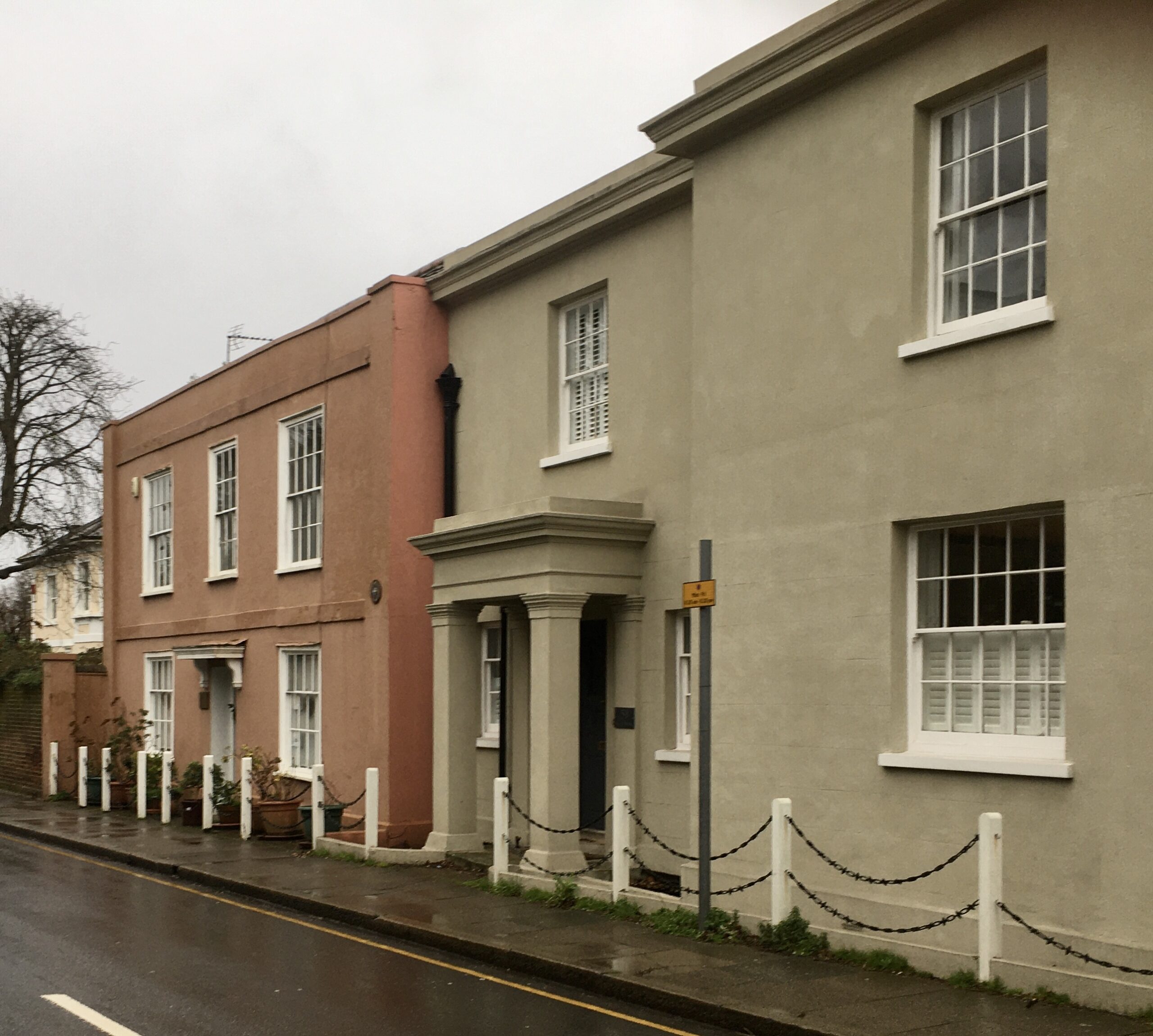 The porticoed entrance to no. 59
Part of the old brewhouse had been retained when the rest was pulled down. This now became the Linford’s lofty garage. Stone House did not have one.
The garden was divided in a curious fashion. Stone House had a small part by the house; the Linfords had their garden in the middle; the rest of the Stone House garden was at the far end. The Linfords could not even see their part of the garden from their house; access to it was only through their two-storey garage and a passage behind Stone House’s kitchen; and the two ends of the Stone House garden were connected by a narrow grass walk at the side of the Linfords part.
Investigations
The need for various repairs and a number of other curiosities have been discovered in the course of our tenure, but I comment here on only two of them: Mathematical Tiles, and The Collapse of the Garden Wall.
Mathematical Tiles
On a couple of occasions when the carpenter was cutting out defective cills, he dislodged ‘mathematical tiles’. These were so shaped that they could be hung vertically like tiles, and be pointed up to have the appearance of ordinary brickwork. I thought then that when Parker did his facelift, he must have used these overall; but further opening up has shown that this was not so; I can only assume that the tiles dislodged had been used to get over some local irregularity.
The Collapse of the Garden Wall
I referred earlier to the fire that destroyed the buildings that the Pagdens had been using on the adjoining Daniel land, and how only one, ill supported wall was left at the back of the Pagden conservatory. It was 14 feet high and had also been extended at that height out towards the street. When we bought the house in 1959 part of the wall was 12 inches out of plumb and leaning towards the neighbour’s land. It was only friction in the mortar joints that was holding it up. I was worried and went to see my neighbour. He was quite blazé – ‘it had been like that for as long as he could remember…. It would see him out’. So, I stopped worrying.
Not long after, a few months later the vibration from pneumatic drills being used some way down the street gave it its coup de grace. I was in the bath at the time after a long day’s work in the garden and my little daughter came running up the stairs calling out ‘ Daddy, Daddy, the wall’s fallen over’. Indeed it had.
Garage
I took the opportunity to apply for planning permission to replace the conservatory with a garage, and finally succeeded. I took care to build piers and design the gates so as to be in keeping with Parker’s facelifted eighteenth century style house.
Working from Home
In 1989 I decided to close my office down the road, and made an addition and work at home. This too had to be in keeping, and I had a struggle with the Council’s Conservation Officer, but I was subsequently flattered when they brought out a pamphlet on ‘Conservation Policy’ which bore an illustration on my extension as an example of their policy.
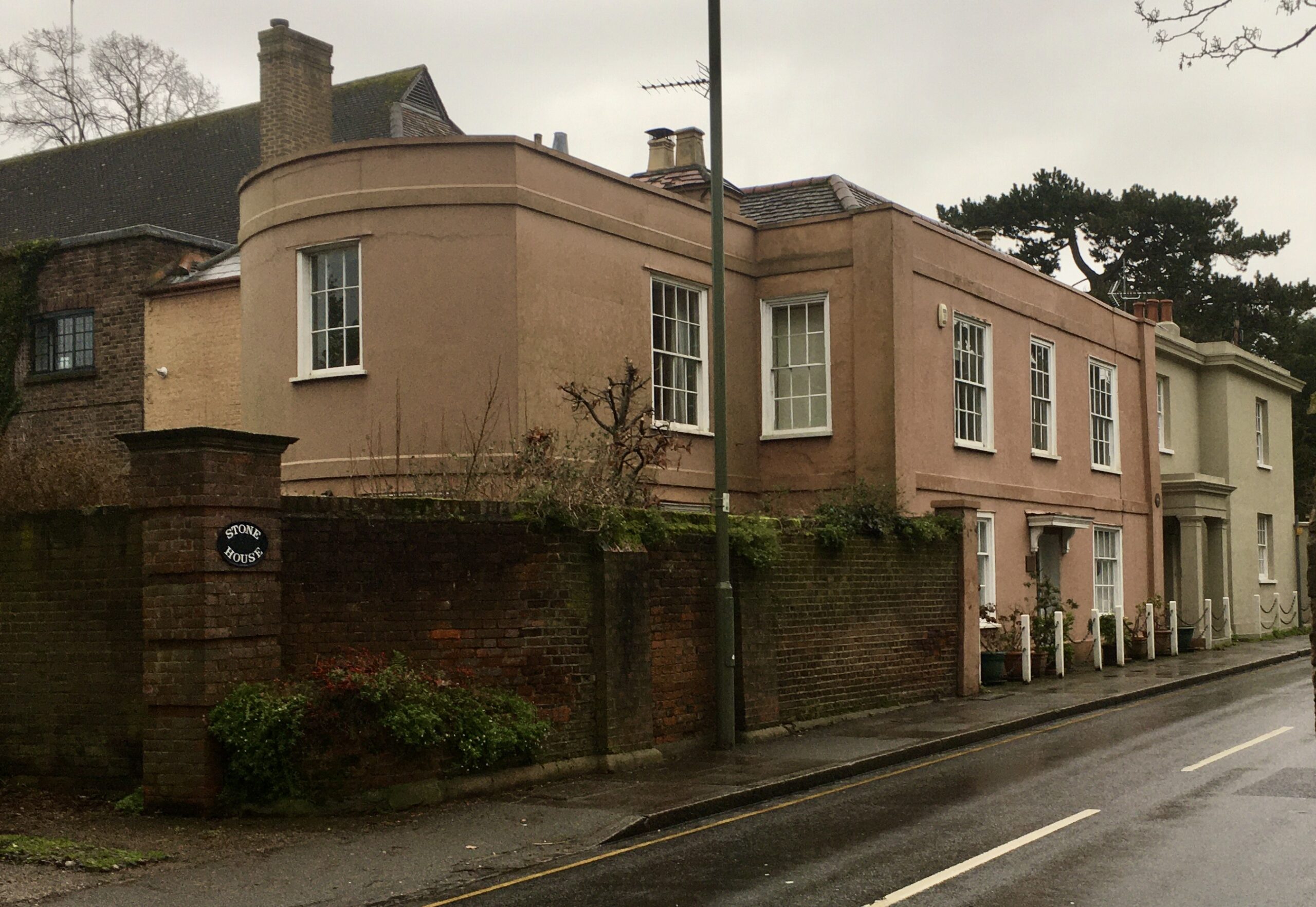 Stone House no. 59a
Stone House and the Town
Stone House is next to the parish church, which is one of the two that William the Conqueror’s Doomsday book told us were here in his time. It was doubtless the centre of village life at that time. As the main road to the coast passed nearby, villagers would have sought to trade with travellers; and so the trade centre shifted to the area around the present Market Place. On Sundays villagers living there had to cross the fields to get to church; as they did so in their ‘Sunday Best’ the path they used came to be known as the Church Parade. Today it is just The Parade.
Stone House, although no mansion, is a house of unusual quality; it is conveniently near the station and shops; but sufficiently removed to be suitable for family life; and for working at home. The rooms are not particularly large, but they are larger than are to be found in most modern houses. The garden is both peaceful and interesting; and I am happy here.
Note: References are made throughout this article to ‘The Residential Copyholds of Epsom’ by H.L. Lehmann. Copies of this book can be viewed at both Epsom Library and Ewell Library, reference LOC 333.3
This personal record of Stone House was given by
Brian Fender to Elaine Parker in 2011