
Other Epsoms
Where else in the World is there an Epsom?
The following articles first appeared in various editions of
Lives and Times
the newsletter of
Epsom & Ewell Local & Family History Centre.
Index
Click on the name to jump to the relevant entry
- Auckland, New Zealand
- Indiana, USA
- New Hampshire, USA
- Ontario, Canada
- Queensland, Australia
- Victoria, Australia
- Still Awaiting Research
Click for our page on Other Ewells.
Epsom, New Hampshire USA.

The town hall of Epsom, NH
Photo by Magicpiano via Wikipedia (CC BY-SA 4.0)
Brief Early Historical Look at Epsom, NH
Google Map Satellite View
Epsom was granted to the taxpayers of Rye, New Castle and Greenland in 1727 by the Governor of Massachusetts, before New Hampshire became an independent province. Epsom was named for Epsom, England, home of the Earl of Derby, whose horse racing ‘derby’ at Epsom Downs was famous. Epsom, England was also known for its mineral springs, the source of Epsom salts.
It wasn’t until the land was surveyed that the first 20 men drew the first 20 fifty acre lots – Seavey, Goss, Berry, Locke, Dowst, Berry, Wallace, Chapman, Foss, Weeks and Marden, to name a few. These were referred to as the “home-lots.” On the 9th of November, the town which had been divided into 4 equal ranges of a mile each in length, and after making a list of the proprietors of the 3 towns (totaling 143) met to draw their several lots. More names: Haines, Tarleton, Rand, Philbrook, Perkins, Dowst, Parker, Cate, Sherburne, Hill, Brackett, Morrill Amazeen, Clark…etc.
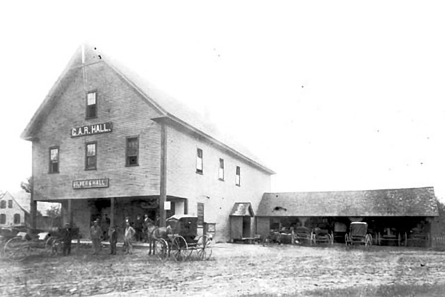
Silver and Hall General Store circa 1890.
The G.A.R. Hall (second story) was
originally the Epsom Baptist Church.
Money for hiring a minister began in 1742, but the first minister, Rev. John Tuck, did not arrive until August 1761. In April 1764, a vote was taken to build a meetinghouse. By 1766 it was in use, but Rev. Tuck’s stay was to be rather
short-lived. A dispute developed between he and some of the town’s folk and he was dismissed and the meetinghouse shut up in 1774. Rev. Benjamin Thurston was in Epsom, 1779, but it was not until 1784 when a full time clergyman returned – Rev. Ebenezer Hazeltine. As much as he was beloved during his tenure, which ended
1813 with his death, his congregation never exceeded the number that Rev. Tuck had. Also of note is the fact that much of the church records of Rev. Tuck
have made their way to the NH Archives. None of Rev. Hazeltine’s records have survived or been found to this day. This leaves a very large amount of vital statistics for the town of Epsom missing.
Rev. Jonathan Curtis succeeded the Congregational cause in 1814. By this time the town began to faction into other religious societies, fighting over the use of the meetinghouse, and this of course did nothing to help the record keeping of the times. Rev. Curtis remained until 1825, but by then there were the Free-Will Baptists, and not long after the Christian Society. In 1845 the Congregationalists had a new building, and in 1861, the Baptists had their second church. The keeping of records, here, as in other towns, were kept rather haphazardly by the
town, no longer being a church function. The town no longer supported any particular church.
There undoubtedly were settlers here before the drawing of the lots, Charles McCoy being the most well known, and he and his family are a story all to themselves. The town did not get off to a fast start due to the Indian Wars, in fact, by the French War of 1745-49, there may have been as few as five families still remaining. In 1761, there were still less than 50 families, but they went about and constructed their meetinghouse, hired a minister. In 1783, permission was given to the town to sell at auction “common land” in the southwestern part of the town; these lots were still 100 acres but were half as long. More familiar names arrive – McClary, Sanborn, Bickford, McGaffey, to name a few.
By 1800 the town became one of the most important in the Suncook Valley, being in a significant location between the coast and the capital in Concord. The first toll road was established in the State toll road appeared in Epsom, and there were several well known taverns to accommodate the many people traveling through town, including one run by one of the earliest families, the McClary’s. Lumber and grist mills could be found on the Suncook and Little Suncook Rivers, and small factories and general stores appeared, several lasting into the middle of this century.
A difficulty in tracing information, besides the lack of church and town records, is that from its beginnings until 1824, Epsom was part of Rockingham County, then switching to the new Merrimack County. Town records were not very well kept until mandated by the State around 1887, when vital statistics began to appear in annual
town reports. Just before 1800, several families removed to start new homes in Stanstead, Canada, and a small exodus to the larger mill towns of Lowell and Lynn, Massachusetts occurred around 1820.
Epsom’s population peaked after the Civil War, and was not to have a significant growth in population again until the 1950’s. Epsom is located in Merrimack County, in the Concord metro area and includes the village of Gossville. The population, at the time of the 2000 census, was 4,021.
Researched and written by Ian Parker 2012
References/Sources:
Epsom, Auckland, New Zealand
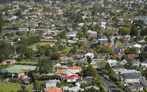
Epsom, Auckland, New Zealand
Photo by Euniceminjeong via Wikipedia (CC BY-SA 4.0)
Epsom is a suburb of Auckland, New Zealand. It is located in the centre of the Auckland isthmus between Mount Eden and One Tree Hill, south of Newmarket, and five km south of the city centre. Population around 6,500.
Google Map Satellite View
Named after the town in England noted for its horse-racing, Epsom also has a race track. The Alexandra Park Raceway lies in the eastern quarter of Epsom where it is located next to the Epsom Showgrounds. The broad, flat pastureland here at the intersection of Greenlane and Manukau Roads was used for sporting events from the 1850s onwards but the two venues were only formally established around 1900. The Alexandra Raceway was named after the then Princess of Wales (later Queen Alexandra). The Epsom Showgrounds are the location of the annual Royal Easter Show.
From the 1840s until the 1890s Epsom was noted for its rich pasture land which supported both dairy herds and grain crops. Towards Mt Eden is Windmill Road which was the site of the Bycroft Windmill. Initially large country houses and farms dotted the landscape but from the 1890s onwards suburban development spread southwards from Newmarket across the fields of Epsom. Most of the housing in the area dates from 1900 to 1930, often large houses built solidly of wood, many in the Californian Bungalow or “Stockbroker Tudor” styles.

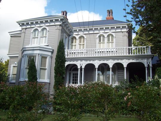 Amohia 127 Mountain Road, Epsom, AUCKLAND 2007
Photo by Lynne Sheather via heritage.org.nz
The area has been long noted for its tree-lined, well-ordered streets, (above upper), parks and a great variety of architecture, with century-old villas (above lower) competing with late 20th century modern housing. Following WWII increasing numbers of the larger properties were subdivided and smaller houses appeared. Since the early 1990s there has been a considerable amount of “infill” housing with clutches of townhouses altering the streetscapes in some parts of Epsom – I will make no comment regarding comparison with our Epsom, Ed.
Researched and written by Ian Parker 2012
References/Sources
- Wikipedia
- Graham W. A. Bush (ed), The History of Epsom (ISBN 9780473111021)
- Epsom & Eden District Historical Society
Epsom, Queensland, Australia
Google Map Satellite View
You’ll find Epsom at an altitude of approximately 784 ft on the Denison Creek, just off the Peak Downs Highway. Denison Creek starts near Pisgah Range at an elevation of 2,400 ft and drops some 1,706 ft over its 58 miles length ending at an elevation of 500 ft when merging with the Funnel Creek. The Peak Downs Highway is 169 miles long linking the towns of Mackay on Queensland’s coast and Clermont, a centre of coal mining in the Central West region of the state. The highway is notorious for the extremely dangerous conditions caused by its service as a primary access route for workers, fuel, machinery and other supplies to the coalmines of the Bowen Basin.
To get back to our subject, the main feature of the area is the Epsom State Forest, which covers some 7,910 acres. It is a good place for bird watching and wildlife but, paradoxically, it is said to be a popular area for off-road motorcycling.
As you will note from this geography lesson, there isn’t much to say about Epsom, Queensland. Still, if you wanted to locate there you could buy Lot 33 in Coal Court. It is a 6,146 sq. ft plot with all services including the National Broadband Network and is close to shops, sporting facilities and public transport. It will set you back around $114,000 (around £76,000), assuming it hasn’t been sold already.
Researched and written by Ian Parker 2013
Epsom, Victoria, Australia
Google Map Satellite View
Epsom is a suburb of the city of Bendigo in central Victoria, Australia, 7 kilometres (4.3 mi) north of the Bendigo central business district and around 100 miles north of Melbourne. At the 2006 census, Epsom had a population of 1,405. Bendigo is the fourth largest inland city in Australia and fourth most populous city in the state with a population of 82,794.
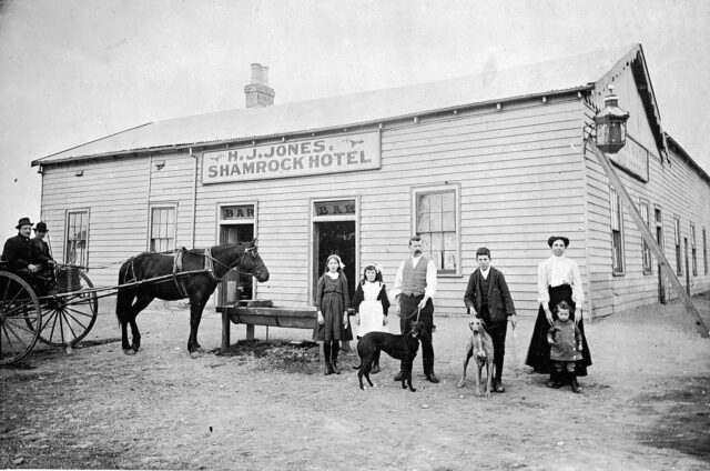 The hotel owner and his family in front of H.J. Jones ‘ Shamrock Hotel. 1912
Image Source Museums Victoria (Item MM 4293)
The founding of Epsom, and Bendigo, is due to the discovery of gold in 1851, which made it one of the most significant Victorian era boomtowns in Australia. The gold could easily be extracted and news of the finds intensified the Victorian gold rush bringing an influx of migrants to the city from around the world within a year and transforming it from a sheep Station to a major settlement in the newly proclaimed Colony of Victoria. By June 1852, at the height of the rush, diggers were said to be arriving on Bendigo at a rate of 5-6,000 a week. Of great interest to the early diggers were the …
“six or seven rounded white hills, ‘unique and peculiar to Bendigo’, which were possessed of a ‘most obdurate hardness’. Many a digger had blunted his pick on them but at length a party of Cornish miners, refusing to accept defeat, drove through them for some sixty or seventy feet. It was backbreaking, slaving toil but suddenly, their picks sank into soft-pipe clay. The men began tunnelling and presently, the roof forming above showered gold at their feet – the secret of the famous White Hills lay revealed … “
A wild rush followed. Within days the tents and stores stretched out to Epsom Flats and some pretty piles (of money) were made from Epsom Flats.
Epsom was an important part of the gold rush. It has been quoted that ‘Epsom diggers were renowned for their skill in sinking deep shafts in alluvial ground’. It also attracted an international influx – in addition to the Cornish, many Italian diggers and even more Italian-speaking Swiss were dispersed about Epsom and by the mid 1860s the largest Chinese encampment was at Epsom (the White Hills Camp), with a population of approximately 1,000.
Since 1851 about 25 million ounces of gold (777 tonnes) have been extracted from Bendigo’s goldmines, making it the highest producing goldfield in Australia in the 19th century and the largest gold mining economy in eastern
Australia.
Today the art of gold mining is displayed in the underground galleries of the Central Deborah Gold Mine close to the city centre. The complex offers visitors an above ground display as well as the chance to put on hard hats and individual lights and descend 61 metres below the surface and explore the shafts.
Epsom is just a short distance from the famous Bendigo Pottery. George Duncan Guthrie (born 1828) was a Glaswegian who, having arrived penniless on the South Australian shore following a shipwreck, tried his luck in the goldfields, failed to find gold but discovered instead a deposit of fine white clay, and started one of Australia’s most illustrious potteries in 1857 and ran it until his death in 1910.
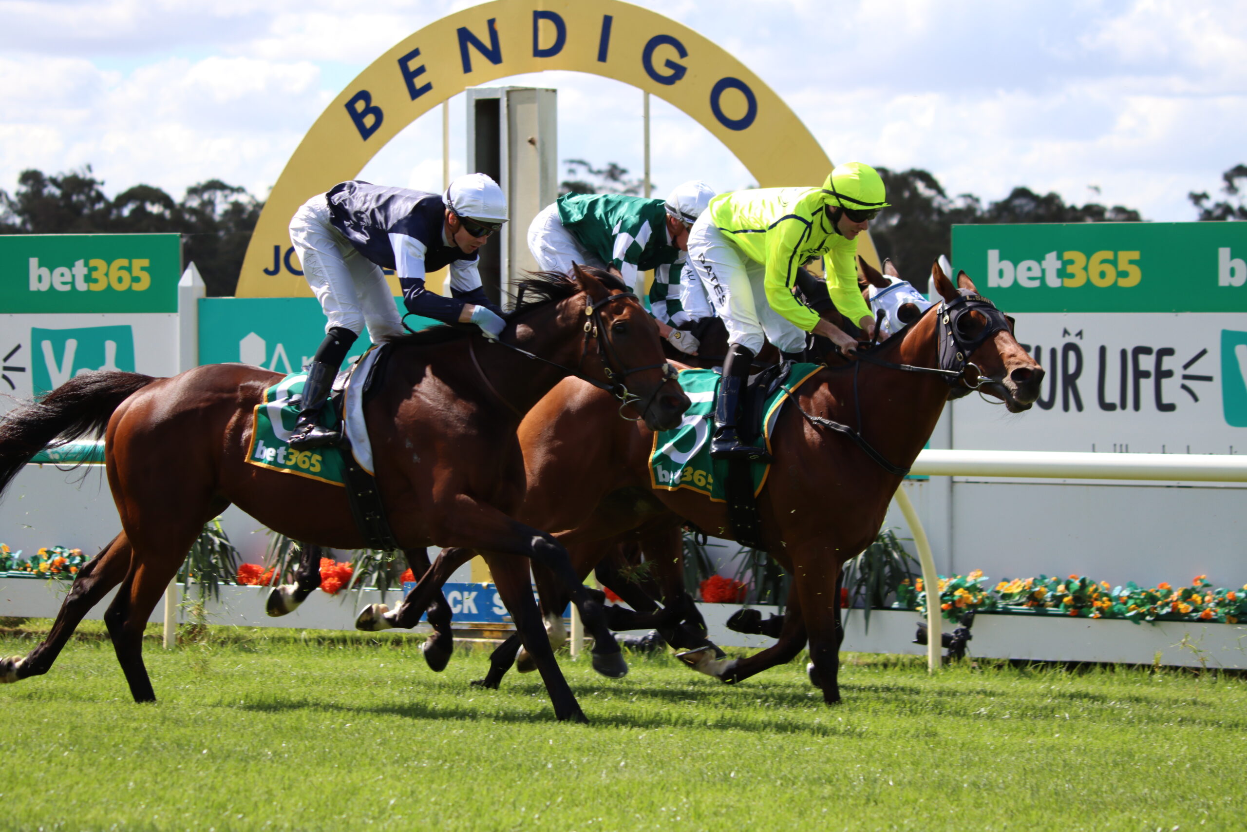 Winning The Golden Mile race at Bendigo Racecourse
Image Source: Bendigo Times
On the south-eastern edge of Epsom is the Bendigo Racecourse, known as the ‘Nursery of Champions’ and has been the launch pad for some of the great careers in Australian racing. It is an eye-catching course that offers some of the most picturesque country racing. It is popular amongst visitors who set up picnics or mini marquees as they watch the races. Coincidentally, there is a suburb called Ascot just to the east of the suburb of Epsom. So, maybe a strong racing community does exist?
Today, Epsom is a quiet suburb of Bendigo, which is the largest finance centre in Victoria outside of Melbourne and is home to Australia’s only provincially headquartered retail bank, the Bendigo Bank, and the Bendigo Stock Exchange. But what an exciting past, it has left Bendigo with an heritage of attractive Victorian buildings.
Researched and written by Ian Parker 2013
Epsom, Indiana, USA
Google Map Satellite View
Epsom is located in Davies’s County, Indiana and, despite being in the heartland of the USA is only 500 feet [152 m] above sea level. It is probably more of a hamlet than a town, as evidenced by the photograph of Main Street (below). There isn’t even a population count for Epsom but within a five mile radius (8 km) there are three communities with a total population of under 2,000, so Epsom is probably a couple of hundred at most. Epsom lies in the Eastern Time Zone but if you travel west for about 40 miles, to a town like Russellville, you will shortly leave the Eastern Time and cross into the Central Time Zone, which must cause some confusion to travellers.
The weather records show it ranges from a low -4° in January to 31° in July/August. The record low is -27° in 1994 and the record high is 45° in 1930. It generally snows from December to March with anywhere from 1” to 3”. Rain averages 4” a month ranging from a low of 3” to nearly 6” at the highest.
 Epsom, Indiana
Image by Chris Flook Source Wikipedia (CC BY-SA 4.0)
You can see from my comments I don’t have much to say about Epsom, Indiana. However, we found an 1866 History of Davies County which states:
“Two miles from Cornettsville, and in the same township, is Epsom, which consists of a half-dozen dwellings, three stores, a post-office and a schoolhouse. The vulgar name of the place is ” Tophet.” The present name was given it because the water from a well in the hamlet that was dug by a Mr. Page was thought to resemble in taste the famous Epsom salts. The first settlement was made away back in 1815, or 1816, by Peter Yount.
Considerable business is done here during the winter season, when the bad roads make it difficult to get to and from Washington. Among the early merchants were Joseph Brown, John Kendall, John Hyatt, Dr. David Carter, William J. Wilson, Hiram Myers, David Young and others. Among the physicians who have practiced and are now practicing here are Drs. David Carter, T. G. Ray, T. V. Norvell and David R. Carter. There are now three small stores carrying lines of general merchandise.”
Washington is Washington, Indiana not Washington, D.C. and is some 15 miles from Epsom. It was a thriving railroad town in 1857 and by 1889 it was a major depot and repair yard for the railway.
Incidentally, I think “Tophet” is a term for ‘hell’, which may say something about the place in 1866. But, based on the report above, maybe Epsom was once a more thriving community.
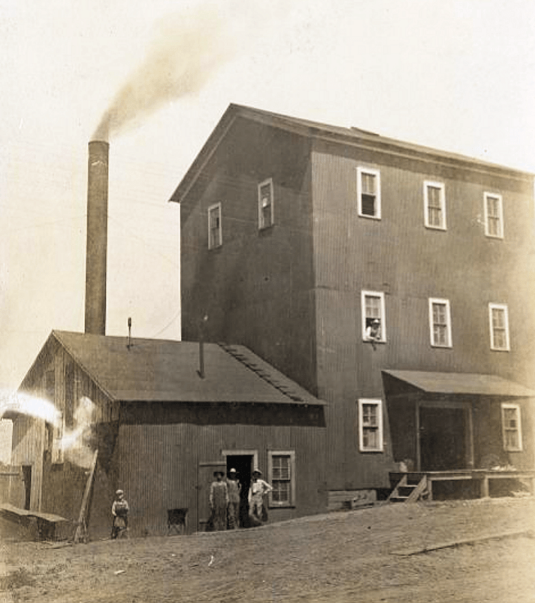 T.C. Myers and Bros. Milling Co., Epsom, Indiana 1909
Image Source Indiana Historical Society (P0336_BOX1_001)
We have found a 1900 image of a milling plant, T.C. Myers and Bros. which was established in Epsom by Thomas Myers. He was born in 1866 and worked in the milling and mercantile business at various points with his brothers Charles and Alfred. For twenty-six years they operated a sawmill as well as building the first flourmill in their hometown of Epsom.
Researched and written by Ian Parker 2014
References/Sources:
- millersofwashingtoncounty.org/Daviess/Chapter-7.html (Site No Longer live)
- indianahistory.org
Epsom, Ontario, Canada
Google Map Satellite View
Epsom is located in south central Ontario between Lakes Huron and Ontario. The nearest town, some 5 miles to the east, is Port Perry on Lake Scugog. Epsom is less than 50 miles northeast of Toronto and is described as being in the Greater Toronto area and many residents in the area commute to Toronto for work on a daily basis. However, the largest private-sector employer in the area is the Great Blue Heron Casino, located on the Scugog First Nation on Scugog Island. The region is also a popular tourist destination due to the casino and recreational opportunities from Lake Scugog.
Epsom itself is on a crossroads of two minor roads running east-west and north-south and is probably more of a hamlet than a village. There isn’t even a population count for Epsom but Port Perry has a population of less than 9,000, so Epsom is probably a few hundred at most. The weather records show it ranges from a low -6° in January to 26° in July/August.
A crossroads in Epsom Ontario showing the old school house
Google Street View
You can see from my comments I don’t have much to say about Epsom, Ontario. However, with a little bit of digging we found some history of the area written by Reverend R. Monteith in 1859.
“The area was surveyed by Major Samuel Wilmot in the year 1809, and he named it ‘Reach’ after a Colonel of that name. Up until the year 1821 there was not a single settler in the area, all was unbroken forest. In the month of May that year, Reuben Crandell, senior, had the courage to settle there. The township had several large swamps and marshes, as it still has, which for a large number of years, were infested with bears, and still more with wolves.
It was not until 1828 that John Ensign laid the foundation of Epsom, and early in 1829 a number of other settlers joined him there. By 1832 there were enough settlers for a partial road from Epsom to the nearby development of Uxbridge. We say partial because it was a bit more than a bridle road and was serviceable for ox-carts. Transport in the region was gradually improving, not only between settlers within the township, but between these settlers and others in neighbouring townships. And as might have been expected, new settlers were attracted into Reach/Epsom.
In 1845 a plank road was opened which was replaced by a gravel road as the planks deteriorated, paid for with Government money. It was later bought by a private company who obtained it for little more than half the original cost. At the same time three much needed schoolhouses were erected in the region; one less than a mile from Epsom was built in 1850; and in 1852 a post office was established at Epsom.
On the afternoon of the 4th July 1850 a dreadful tornado storm hit the township of Reach/Epsom. Its effects were appalling, destroying trees, houses, mills and farm offices and injuring and even killing animals and humans alike.”
And that is it, except that we did discover a personal recollection of Simon Miller, who was living in Ontario and whose immediate ancestors were connected with the very earliest stages in the history of Toronto. The following comment was told to Mr. Miller in 1906 by a Mr. John Claughton, and is an illustration of the change in Ontario in the course of one lifetime.
“I was on my way from Barrie to Whitby when night found me with a very tired horse, near Epsom, in the township of Reach. There was not a house of public accommodation within miles”.
And yet Mr. Claughton remembered when Epsom had two hotels; Prince Albert, three; and Utica and Manchester, two each—all the places named being within a few miles of each other.
“Where are the pioneers and their descendants`?” asked Mr. Miller. The answer came in something like a wail: “Gone, gone—gone almost to the last man and the last woman. The bodies of the pioneers lie in neglected or forgotten cemeteries. Their descendants have been scattered as if by the four winds of heaven. In many cases even the names are forgotten. Of the families living between Whitby and Oshawa in the 1840s I do not believe one remains to-day. Between Manchester and Whitby it is much the same. Only two or three remain between Epsom and Manchester.”
So it seems that since then Epsom has remained a quiet backwater on a minor crossroad to the west of Port Perry on the way to Toronto.
Researched and written by Ian Parker 2016
Sources:
- Scugog Heritage Maps.
- History of the Township of Reach by Reverend R. Monteith, 1859
- Scugog History
- Simon Miller
- Google Earth
Still Awaiting Research
These Epsoms still need to be researched. If you can help or have any information on these and other Epsoms please contact us.
- Epsom Guyana-East Berbice-Corentyne
- Epsom Jamaica-Saint Mary
- Epsom South Africa-KwaZulu-Natal
- Epsom South Africa-Limpopo
- Epsom South Africa-Northern Cape
- Epsom USA-North Carolina
- Epsom USA-Minnesota
- Epsom Zimbabwe-Manicaland
There are even more places called Epsom (see geonames.org) but these appear to be tiny places which we can find little or no readily available information.